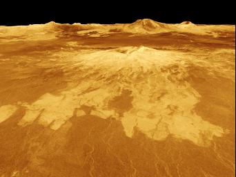
Venus - 3-D Perspective View of Sapas Mons
Caption:
Sapas Mons is displayed in the center of this computer-generated three-dimensional perspective view of the surface of Venus. The viewpoint is located 527 kilometers (327 miles) northwest of Sapas Mons at an elevation of 4 kilometers (2.5 miles) above the terrain. Lava flows extend for hundreds of kilometers across the fractured plains shown in the foreground to the base of Sapas Mons. The view is to the southeast with Sapas Mons appearing at the center with Maat Mons located in the background on the horizon. Sapas Mons, a volcano 400 kilometers (248 miles) across and 1.5 kilometers (0.9 mile) high is located at approximately 8 degrees north latitude, 188 degrees east longitude, on the western edge of Atla Regio. Its peak sits at an elevation of 4.5 kilometers (2.8 miles) above the planet's mean elevation. Sapas Mons is named for a Phoenician goddess. The vertical scale in this perspective has been exaggerated 10 times. Rays cast in a computer intersect the surface to create a three-dimensional perspective view. Simulated color and a digital elevation map developed by the U.S. Geological Survey are used to enhance small-scale structure. The simulated hues are based on color images recorded by the Soviet Venera 13 and 14 spacecraft. The image was produced by the Solar System Visualization project and the Magellan Science team at the JPL Multimission Image Processing Laboratory and is a single frame from a video released at the April 22, 1992 news conference.
Cataloging Keywords:
| Name |
Value |
Additional Values |
| Target |
Venus |
|
| System |
|
|
| Target Type |
Planet |
|
| Mission |
Magellan |
|
| Instrument Host |
Magellan |
|
| Host Type |
Orbiter |
|
| Instrument |
Imaging Radar |
|
| Detector |
|
|
| Extra Keywords |
Color, Map, Mountain, Volcano |
| Acquisition Date |
|
| Release Date |
1996-11-12 |
| Date in Caption |
1992-04-22 |
|
| Image Credit |
NASA/JPL |
| Source |
photojournal.jpl.nasa.gov/catalog/PIA00107 |
| Identifier |
PIA00107 |

