Venus - False Color Image of Alpha Regio
Caption:
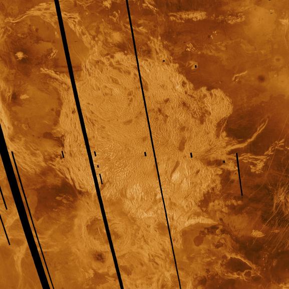
This Magellan radar image shows Alpha Regio, a topographic upland approximately 1,300 kilometers (806 miles) across which is centered on 25 degrees south latitude, 4 degrees east longitude. In 1963 Alpha Regio was the first feature on Venus to be identified from Earth based radar. The radar bright area of Alpha Regio is characterized by multiple sets of intersecting trends of structural features such as ridges, troughs and flat floored fault valleys that together form a polygonal outline. Circular to oblong dark patches within the complex terrain are local topographic lows that are filled with smooth volcanic lava. Complex ridged terrains such as Alpha, formerly called "tessera" in the Soviet Venera 15 and 16 radar missions and the Arecibo radar data, appear to be widespread and common surface expressions of Venusian tectonic processes. Directly south of the complex ridged terrain is a large ovoid shaped feature named Eve. The radar bright spot located centrally within Eve marks the location of the prime meridian of Venus. Magellan radar data reveals that relatively young lava flows emanate from Eve and extends into the southern margin of the ridged terrain at Alpha. The mosaic was produced by Eric de Jong and Myche McAuley in the JPL Multimission Image Processing Laboratory.
Cataloging Keywords:
| Name |
Value |
Additional Values |
| Target |
Venus |
|
| System |
|
|
| Target Type |
Planet |
|
| Mission |
Magellan |
National Astronomy and Ionosphere Center (NAIC) |
| Instrument Host |
Magellan |
Arecibo Observatory |
| Host Type |
Orbiter |
Ground-Based Observatory |
| Instrument |
Imaging Radar |
Arecibo Radar |
| Detector |
|
|
| Extra Keywords |
Color, Radar, Volcano |
| Acquisition Date |
|
| Release Date |
1996-02-07 |
| Date in Caption |
|
|
| Image Credit |
NASA/JPL |
| Source |
photojournal.jpl.nasa.gov/catalog/PIA00147 |
| Identifier |
PIA00147 |