|
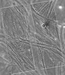
Ganymede - Galileo Mosaic Overlayed on Voyager Data in Uruk Sulcus Region
- Click the image above for a larger view
- Full-Res JPEG (1443 x 1656) (406.5 kB)
- Full-Res TIFF (1443 x 1656) (2.3 MB)
Caption:
A mosaic of four Galileo high-resolution images of the Uruk Sulcus region of Jupiter's moon Ganymede is shown within the context of an image of the region taken by Voyager 2 in 1979. The image shows details of parallel ridges and troughs that are the principal features in the brighter regions of Ganymede. The Galileo frames unveil the fine-scale topography of Ganymede's ice-rich surface, permitting scientists to develop a detailed understanding of the processes that have shaped Ganymede. Resolution of the Galileo images is 74 meters (243 feet) per pixel, while resolution of the Voyager image is 1.3 kilometers (0.8 mile) per pixel. In this view, north is to the top, and the sun illuminates the surface from the lower left nearly overhead. The area shown, at latitude 10 degrees north, longitude 168 degrees west, is about 120 by 110 kilometers (75 by 68 miles) in extent. The image was taken June 27 at a range of 7,448 kilometers (4,628 miles).
Background Info:
The Jet Propulsion Laboratory manages the Galileo mission for NASA's Office of Space Science.
Cataloging Keywords:
| Name | Value | Additional Values |
|---|---|---|
| Target | Ganymede | |
| System | Jupiter | |
| Target Type | Satellite | |
| Mission | Galileo | Voyager |
| Instrument Host | Galileo Orbiter | |
| Host Type | Orbiter | Flyby Spacecraft |
| Instrument | Solid-State Imaging (SSI) | |
| Detector | ||
| Extra Keywords | Grayscale | |
| Acquisition Date | ||
| Release Date | 1997-09-07 | |
| Date in Caption | ||
| Image Credit | NASA/JPL | |
| Source | photojournal.jpl.nasa.gov/catalog/PIA00281 | |
| Identifier | PIA00281 | |
