skip to navigation

|
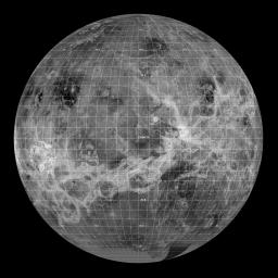
Venus - Global View Centered at 180 degrees
- Click the image above for a larger view
- Full-Res JPEG (10240 x 10240) (8.5 MB)
- Full-Res TIFF (10240 x 10240) (44.9 MB)
Caption:
This global view of the surface of Venus is centered at 180 degrees east longitude. Magellan synthetic aperture radar mosaics from the first cycle of Magellan mapping, and a 5 degree latitude-longitude grid, are mapped onto a computer-simulated globe to create this image. Data gaps are filled with Pioneer-Venus Orbiter data, or a constant mid-range value. The image was produced by the Solar System Visualization project and the Magellan Science team at the JPL Multimission Image Processing Laboratory.
Cataloging Keywords:
| Name | Value | Additional Values |
|---|---|---|
| Target | Venus | |
| System | ||
| Target Type | Planet | |
| Mission | Magellan | |
| Instrument Host | Magellan | |
| Host Type | Orbiter | |
| Instrument | Imaging Radar | |
| Detector | ||
| Extra Keywords | Grayscale, Radar | |
| Acquisition Date | ||
| Release Date | 1996-11-26 | |
| Date in Caption | ||
| Image Credit | NASA/JPL | |
| Source | photojournal.jpl.nasa.gov/catalog/PIA00478 | |
| Identifier | PIA00478 | |
