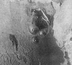
Venus - Volcanic Domes on Flank of Volcanic Maat in East Ovda Region
Caption:
This Magellan image is centered about 3.2 degrees north latitude, 194.9 degrees longitude in the eastern Ovda region of Venus. The image, which is 90 km (56 miles) in width and 80 km (50 miles) in length, shows some small volcanic domes on the flank of the volcano Maat. The bright flows to the east are most likely rough lava flows while the darker flows to the west are probably smoother flows. The dark flows do show some roughness, however, as can be seen by the structure in the flows to the southwest. These dark flows also have some debris that has been deposited on top of the flows. The debris may be fine material from the surrounding plains on top of the flow by wind or it may be ash from the volcano. Small volcanic domes are very common features on the surface of Venus, indicating that there has been much volcanic activity on the surface. Assuming that the central volcanic cone is symmetrical in shape and knowing the length of the cone's side and the incidence angle, radar foreshortening yields a height and slope of 688 meters and 8.2 degrees, respectively for the cone. These values are similar to heights and slopes of some volcanic cones on the Earth.
Cataloging Keywords:
| Name |
Value |
Additional Values |
| Target |
Venus |
|
| System |
|
|
| Target Type |
Planet |
|
| Mission |
Magellan |
|
| Instrument Host |
Magellan |
|
| Host Type |
Orbiter |
|
| Instrument |
Imaging Radar |
|
| Detector |
|
|
| Extra Keywords |
Grayscale, Radar, Volcano |
| Acquisition Date |
|
| Release Date |
1996-11-14 |
| Date in Caption |
|
|
| Image Credit |
NASA/JPL |
| Source |
photojournal.jpl.nasa.gov/catalog/PIA00487 |
| Identifier |
PIA00487 |

