|
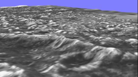
Stereo View of Ganymede’s Galileo Regio
- Click the image above for a larger view
- Full-Res JPEG (1920 x 1080) (178.4 kB)
- Full-Res TIFF (1920 x 1080) (2.4 MB)
Caption:
New topographic detail is seen in a stereoscopic view of this part of Jupiter's moon Ganymede. The newly processed picture is a computer reconstruction from two images taken by NASA's Galileo spacecraft this summer. One image of the Galileo Regio region was taken June 27, 1996, at a range of 9,515 kilometers (about 5,685 miles) and the other was taken at a range of 10,220 kilometers (about 6,350 miles) on September 6, 1996. The topographic nature of the deep furrows and impact craters that cover this portion of Ganymede is apparent. The blue-sky horizon is artificial.
Background Info:
The Jet Propulsion Laboratory, Pasadena, CA, manages the mission for NASA's Office of Space Science, Washington, DC. This image and other images and data received from Galileo are posted on the Galileo mission home page on the World Wide Web at http://galileo.jpl.nasa.gov. Background information and educational context for the images can be found at http://www.jpl.nasa.gov/galileo/sepo .
Cataloging Keywords:
| Name | Value | Additional Values |
|---|---|---|
| Target | Ganymede | |
| System | Jupiter | |
| Target Type | Satellite | |
| Mission | Galileo | |
| Instrument Host | Galileo Orbiter | |
| Host Type | Orbiter | |
| Instrument | Solid-State Imaging (SSI) | |
| Detector | ||
| Extra Keywords | Color, Crater, Impact | |
| Acquisition Date | ||
| Release Date | 1997-11-18 | |
| Date in Caption | 1996-06-27 | 1996-09-06 |
| Image Credit | NASA/JPL | |
| Source | photojournal.jpl.nasa.gov/catalog/PIA00498 | |
| Identifier | PIA00498 | |
