|
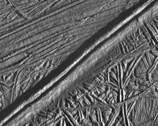
Mosaic of Europa’s Ridges, Craters
- Click the image above for a larger view
- Full-Res JPEG (1160 x 930) (167.4 kB)
- Full-Res TIFF (1160 x 930) (1.1 MB)
Caption:
This view of the icy surface of Jupiter's moon, Europa, is a mosaic of two pictures taken by the Solid State Imaging system on board the Galileo spacecraft during a close flyby of Europa on February 20, 1997. The pictures were taken from a distance of 2,000 kilometers (1,240 miles). The area shown is about 14 kilometers by 17 kilometers (8.7 miles by 10.6 miles), and has a resolution of 20 meters (22 yards) per pixel. Illumination is from the right (east). The picture is centered at about 14.8 north latitude, 273.8 west longitude, in Europa's trailing hemisphere.
One of the youngest features seen in this area is the double ridge cutting across the picture from the lower left to the upper right. This double ridge is about 2.6 kilometers (1.6 miles) wide and stands some 300 meters (330 yards) high. Small craters are most easily seen in the smooth deposits along the south margin of the prominent double ridge, and in the rugged ridged terrain farther south. The complexly ridged terrain seen here shows that parts of the icy crust of Europa have been modified by intense faulting and disruption, driven by energy from the planet's interior.
Background Info:
The Jet Propulsion Laboratory, Pasadena, CA, manages the mission for NASA's Office of Space Science, Washington D.C. This image and other images and data received from Galileo are posted on the World Wide Web Galileo mission home page at: http://galileo.jpl.nasa.gov.
Cataloging Keywords:
| Name | Value | Additional Values |
|---|---|---|
| Target | Europa | |
| System | Jupiter | |
| Target Type | Satellite | |
| Mission | Galileo | |
| Instrument Host | Galileo Orbiter | |
| Host Type | Orbiter | |
| Instrument | Solid-State Imaging (SSI) | |
| Detector | ||
| Extra Keywords | Crater, Grayscale | |
| Acquisition Date | ||
| Release Date | 1998-02-04 | |
| Date in Caption | 1997-02-20 | |
| Image Credit | NASA/JPL/ASU | |
| Source | photojournal.jpl.nasa.gov/catalog/PIA00589 | |
| Identifier | PIA00589 | |
