|
NIMS G1 Observation of Europa
- Click the image above for a larger view
- Full-Res JPEG (1279 x 676) (80.6 kB)
- Full-Res TIFF (1279 x 676) (537.6 kB)
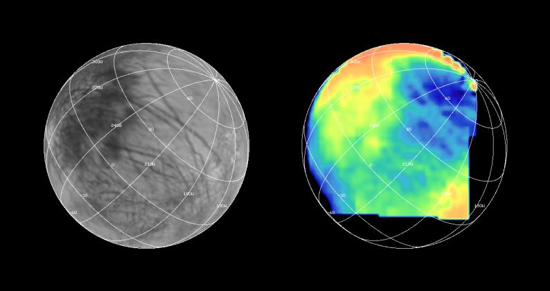
Caption:
The Near Infrared Mapping Spectrometer (NIMS) on the Galileo spacecraft imaged most of Europa, including the north polar regions, at high spectral resolution at a range of 156,000 km (97,500 miles) during the G1 encounter on June 28 1996. The image on the right shows Europa as seen by NIMS, centered on 25 degrees N latitude, 220 W longitude. This is the hemisphere that always faces away from Jupiter. The image on the left shows the same view point from the Voyager data (from the encounters in 1979 and 1980). The NIMS image is in the 1.5 micron water band, in the infrared part of the spectrum. Comparison of the two images, infrared to visible, shows a marked brightness contrast in the NIMS 1.5 micron water band from area to area on the surface of Europa, demonstrating the sensitivity of NIMS to compositional changes. NIMS spectra show surface compositions ranging from pure water ice to mixtures of water and other minerals which appear bright in the infrared.
Background Info:
The Jet Propulsion Laboratory, Pasadena, CA manages the mission for NASA's Office of Space Science, Washington, DC.
This image and other images and data received from Galileo are posted on the World Wide Web, on the Galileo mission home page at URL http://www.jpl.nasa.gov/galileo/sepo .
Cataloging Keywords:
| Name | Value | Additional Values |
|---|---|---|
| Target | Europa | Jupiter |
| System | Jupiter | |
| Target Type | Satellite | Planet |
| Mission | Galileo | Voyager |
| Instrument Host | Galileo Orbiter | |
| Host Type | Orbiter | Flyby Spacecraft |
| Instrument | Near-Infrared Mapping Spectrometer (NIMS) | |
| Detector | ||
| Extra Keywords | Color, Infrared, Water | |
| Acquisition Date | ||
| Release Date | 1998-03-26 | |
| Date in Caption | ||
| Image Credit | NASA/JPL | |
| Source | photojournal.jpl.nasa.gov/catalog/PIA00834 | |
| Identifier | PIA00834 | |