|
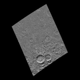
Craters Near the South Pole of Callisto
- Click the image above for a larger view
- Full-Res JPEG (800 x 800) (49.2 kB)
- Full-Res TIFF (800 x 800) (193.9 kB)
Caption:
This image of the south polar region of the Jovian satellite Callisto was taken in twilight by the Galileo spacecraft on its eighth orbit around Jupiter. Craters ranging in size from 60 kilometers (36 miles) down to the limit of resolution are visible in this image. Scientists count the number of craters on a planetary surface to estimate its relative (and sometimes absolute) age. Note that many of the craters are not as sharp in appearance as the two large craters near the bottom of the image. This is an indication that some process has eroded the craters since their formation.
This image is centered at 82.5 south latitude and 62.6 west longitude, and covers an area approximately 370 kilometers (220 miles) by 280 kilometers (170 miles). North is toward the top of the image. This image was taken on May 6, 1997 by the Solid State Imaging system (CCD) on board NASA's Galileo spacecraft at a resolution of 676 meters (417 feet) per picture element.
Background Info:
The Jet Propulsion Laboratory, Pasadena, CA manages the mission for NASA's Office of Space Science, Washington, DC.
This image and other images and data received from Galileo are posted on the World Wide Web, on the Galileo mission home page at URL http://galileo.jpl.nasa.gov. Background information and educational context for the images can be found at http://www.jpl.nasa.gov/galileo/sepo .
Cataloging Keywords:
| Name | Value | Additional Values |
|---|---|---|
| Target | Callisto | Jupiter |
| System | Jupiter | |
| Target Type | Satellite | Planet |
| Mission | Galileo | |
| Instrument Host | Galileo Orbiter | |
| Host Type | Orbiter | |
| Instrument | Solid-State Imaging (SSI) | |
| Detector | ||
| Extra Keywords | Crater, Grayscale | |
| Acquisition Date | ||
| Release Date | 1998-03-26 | |
| Date in Caption | 1997-05-06 | |
| Image Credit | NASA/JPL/University of Arizona | |
| Source | photojournal.jpl.nasa.gov/catalog/PIA00876 | |
| Identifier | PIA00876 | |
