|
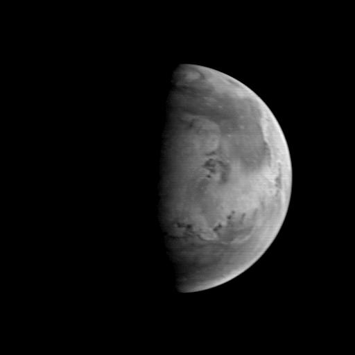
MGS Approach Image - 82.1° W Longitude
- Click the image above for a larger view
- Full-Res JPEG (512 x 512) (9.5 kB)
- Full-Res TIFF (512 x 512) (44.9 kB)
Caption:
The Mars Orbiter Camera (MOC) took this image on August 20, 1997, when the Mars Global Surveyor (MGS) was 5.67 million kilometers (3.52 million miles) and 22 days from entering orbit. At this distance, the MOC's resolution is about 21.2 km per picture element, and the 6800 km (4200 mile) diameter planet is about 327 pixels across. North is at the top of the image. The MGS spacecraft pointed the camera at the center of the planet (near the dark, morning sunrise line, or terminator) at 23.6° N, 82.1° W. At this distance from Mars, only bright and dark markings resulting from variations in the amount and thickness of dust and sand are visible. The large dark marking stretching from the right center northward is Acidalia Planitia, a region of rock and sand with less dust on it than the area immediately to the south, Chryse Planitia. Both Viking Lander 1 and Pathfinder landed in the latter, bright area. In this low resolution image, some of the dark features resemble the "canals" seen prominently in maps created by astronomers of the 19th and early 20th century. Mariner 9 and Viking images show that most of these dark lines are associated with sand deposits that are trapped in rough areas.
Background Info:
Malin Space Science Systems and the California Institute of Technology built the MOC using spare hardware from the Mars Observer mission. MSSS operates the camera from its facilities in San Diego, CA. The Jet Propulsion Laboratory operates the Mars Global Surveyor spacecraft with its industrial partner, Lockheed Martin Astronautics, from facilities in Pasadena, CA and Denver, CO.
Cataloging Keywords:
| Name | Value | Additional Values |
|---|---|---|
| Target | Mars | |
| System | ||
| Target Type | Planet | |
| Mission | Mars Global Surveyor (MGS) | Mariner, Viking |
| Instrument Host | Mars Global Surveyor | |
| Host Type | Orbiter | Flyby Spacecraft |
| Instrument | Mars Orbiter Camera (MOC) | |
| Detector | ||
| Extra Keywords | Dust, Grayscale | |
| Acquisition Date | ||
| Release Date | 1997-09-10 | |
| Date in Caption | 1997-08-20 | |
| Image Credit | NASA/JPL/Malin Space Science Systems | |
| Source | photojournal.jpl.nasa.gov/catalog/PIA00932 | |
| Identifier | PIA00932 | |