|
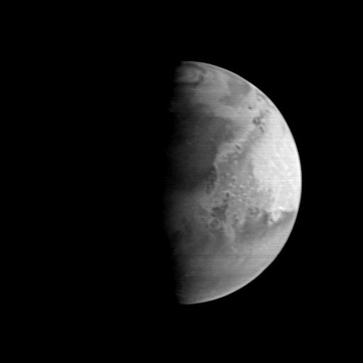
MGS Approach Image - 37.2° W Longitude
- Click the image above for a larger view
- Full-Res JPEG (512 x 512) (9.6 kB)
- Full-Res TIFF (512 x 512) (47.3 kB)
Caption:
This image of Mars shows an area centered near the Pathfinder landing site. The dark area north of the center of the image along the sunrise terminator is Acidalia Planitia--the Pathfinder landing site is about a third of the way down from this dark area across the light Chryse plains. The bright area near the edge of the planet is Arabia. The lower 40% of the image contains the Xanthe, Margaritifer, and Meridiani highlands, heavily-cratered, ancient areas of the most intense erosion seen on Mars. These will be among the more important targets of the MOC when it begins detailed studies in March 1998.
Background Info:
Malin Space Science Systems and the California Institute of Technology built the MOC using spare hardware from the Mars Observer mission. MSSS operates the camera from its facilities in San Diego, CA. The Jet Propulsion Laboratory operates the Mars Global Surveyor spacecraft with its industrial partner, Lockheed Martin Astronautics, from facilities in Pasadena, CA and Denver, CO.
Cataloging Keywords:
| Name | Value | Additional Values |
|---|---|---|
| Target | Mars | |
| System | ||
| Target Type | Planet | |
| Mission | Mars Global Surveyor (MGS) | |
| Instrument Host | Mars Global Surveyor | |
| Host Type | Orbiter | |
| Instrument | Mars Orbiter Camera (MOC) | |
| Detector | ||
| Extra Keywords | Crater, Dust, Grayscale | |
| Acquisition Date | ||
| Release Date | 1997-09-10 | |
| Date in Caption | ||
| Image Credit | NASA/JPL/Malin Space Science Systems | |
| Source | photojournal.jpl.nasa.gov/catalog/PIA00935 | |
| Identifier | PIA00935 | |