|
Magnetic Sources in the Crust of Mars
- Click the image above for a larger view
- Full-Res JPEG (715 x 572) (50.9 kB)
- Full-Res TIFF (715 x 572) (360.8 kB)
Caption:
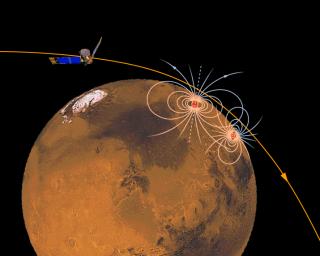
This is a simple schematic representation of localized magnetic sources in the crust of Mars, buried beneath the surface, and revealed by observation of the magnetic field (blue) extending up to satellite altitude (about 120 kilometers). Most of our close passes to date - for which we have data - reveal the presence of one or more magnetic anomalies close to the path of the spacecraft. Since the sources must be close to the path of the satellite, we can only infer that the crust of Mars is strewn with similar magnetic anomalies, awaiting discovery. Where we can obtain enough data - that is to say, spaced more or less evenly in longitude with a spacing comparable to our periapsis altitude - we can construct a detailed image of the magnetic state of the Martian crust. We can then perhaps learn about the history of the now-extinct early Mars dynamo and the evolution of the surface of Mars.
Background Info:
The Jet Propulsion Laboratory's Mars Surveyor Operations Project operates the Mars Global Surveyor spacecraft with its industrial partner, Lockheed Martin Astronautics, from facilities in Pasadena, CA and Denver, CO. JPL is an operating division of California Institute of Technology (Caltech).
Cataloging Keywords:
| Name | Value | Additional Values |
|---|---|---|
| Target | Mars | |
| System | ||
| Target Type | Planet | |
| Mission | Mars Global Surveyor (MGS) | |
| Instrument Host | Mars Global Surveyor | |
| Host Type | Orbiter | |
| Instrument | Magnetometer | |
| Detector | ||
| Extra Keywords | Color, Dust, Magnetosphere | |
| Acquisition Date | ||
| Release Date | 1997-10-13 | |
| Date in Caption | ||
| Image Credit | NASA/JPL/GSFC | |
| Source | photojournal.jpl.nasa.gov/catalog/PIA00949 | |
| Identifier | PIA00949 | |
