|
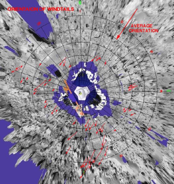
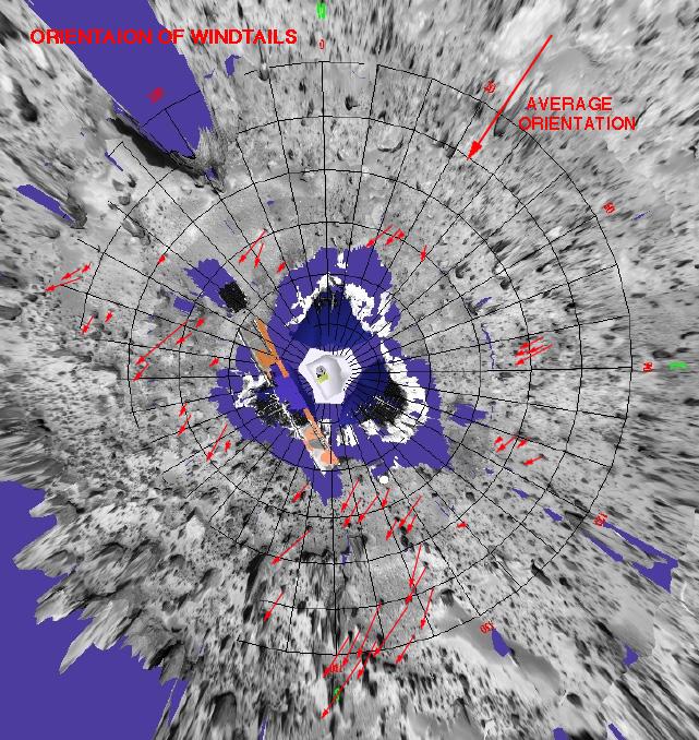
Orientation of Windtails at Pathfinder Landing Site
- Click the image above for a larger view
- Full-Res JPEG (641 x 678) (137.5 kB)
- Full-Res TIFF (641 x 678) (859.1 kB)
Caption:
This is a representation of sediment tails noted at the Mars Pathfinder landing site. The arrows in the figure represent the inferred downwind direction, based on our understanding of the deposition of very fine sediment around surface rocks. The inferred wind direction therefore, is from the northeast blowing toward the southwest. This wind trend matched that of light and dark "streaks" of sediment in and around Martian craters in the region that have were seen by the Viking spacecraft. The detailed map was prepared by Mars Pathfinder scientists from Arizona State University on a base image created by MPF scientists from the NASA Ames research facility.
Background Info:
Mars Pathfinder is the second in NASA's Discovery program of low-cost spacecraft with highly focused science goals. The Jet Propulsion Laboratory, Pasadena, CA, developed and manages the Mars Pathfinder mission for NASA's Office of Space Science, Washington, D.C. JPL is a division of the California Institute of Technology (Caltech).
Photojournal note: Sojourner spent 83 days of a planned seven-day mission exploring the Martian terrain, acquiring images, and taking chemical, atmospheric and other measurements. The final data transmission received from Pathfinder was at 10:23 UTC on September 27, 1997. Although mission managers tried to restore full communications during the following five months, the successful mission was terminated on March 10, 1998.
Cataloging Keywords:
| Name | Value | Additional Values |
|---|---|---|
| Target | Mars | |
| System | ||
| Target Type | Planet | |
| Mission | Mars Pathfinder (MPF) | Viking |
| Instrument Host | Mars Pathfinder Lander | |
| Host Type | Lander | |
| Instrument | Imager for Mars Pathfinder (IMP) | |
| Detector | ||
| Extra Keywords | Atmosphere, Color, Crater, Map | |
| Acquisition Date | ||
| Release Date | 1997-10-14 | |
| Date in Caption | ||
| Image Credit | NASA/JPL/ASU | |
| Source | photojournal.jpl.nasa.gov/catalog/PIA00972 | |
| Identifier | PIA00972 | |