|
Hubble’s Look at Mars Shows Canyon Dust Storm, Cloudy Conditions for Pathfinder Landing
- Click the image above for a larger view
- Full-Res JPEG (2400 x 3000) (377.4 kB)
- Full-Res TIFF (2400 x 3000) (9.5 MB)
Caption:
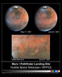
NASA's Hubble Space Telescope images of Mars, taken on June 27, 1997, reveal a significant dust storm which fills much of the Valles Marineris canyon system and extends into Xanthe Terra, about 600 miles (1000 kilometers) south of the landing site.
It is difficult to predict the evolution of this storm and whether it will affect the Pathfinder observations.
The pictures were taken in order to monitor the site in Ares Vallis where the Pathfinder spacecraft will land on July 4.
The two images of Mars at the top of the figure are Hubble observations from June 27 (right) and May 17 (left). Visual comparison of these two images clearly shows the dust storm between 5 and 7 o'clock and about 2/3 of the way from the center of the planet's disk to the southern edge of the June image.
The digital data were projected to form the map of the equatorial portion of the planet which is shown in the bottom portion of the figure. The green cross marks the location of the Pathfinder landing site, and the yellowish ribbon of dust which runs horizontally across the bottom of the map traces the location of Valles Marineris, a system of canyons which would stretch from Los Angeles to New York if placed on Earth.
Most of the dust is confined within the canyons, which are up to 5-8 kilometers deep. The thickness of the dust cloud near the eastern end of the storm is similar to that observed by Viking lander 1 during the first of the two 1977 global dust storms which it studied.
Other interesting features appear in this image. The northwestern portions of the planet are enveloped in unusually thick water ice clouds, similar to cirrus clouds on Earth; some clouds extend as far as Lunae Planum, the slightly darker region about halfway from the center to the left side of the map. The dark spot near the terminator (boundary between day and night) at about 9:00 in the June 27 planet image is Ascraeus Mons, a 27 kilometer high volcano, protruding through the clouds.
The remnant north polar cap, composed of water ice, is at the top of the May and June images, and a bluish south polar hood, composed of water ice clouds, is seen along the southern edge. Because the planet's axis is tipped towards us during this season, we cannot see the south polar cap, which is in winter darkness.
Background Info:
This image and other images and data received from the Hubble Space Telescope are posted on the World Wide Web on the Space Telescope Science Institute home page at URL http://oposite.stsci.edu/ .
Cataloging Keywords:
| Name | Value | Additional Values |
|---|---|---|
| Target | Mars | |
| System | ||
| Target Type | Planet | |
| Mission | Hubble Space Telescope (HST) | Mariner, Viking |
| Instrument Host | Hubble Space Telescope | |
| Host Type | Space Telescope | Flyby Spacecraft |
| Instrument | Wide Field/Planetary Camera 2 (WFPC2) | |
| Detector | ||
| Extra Keywords | Atmosphere, Color, Dust, Map, Mountain, Storm, Volcano, Water | |
| Acquisition Date | ||
| Release Date | 1998-05-02 | |
| Date in Caption | 1997-06-27 | |
| Image Credit | JPL/NASA/STScI | |
| Source | photojournal.jpl.nasa.gov/catalog/PIA01245 | |
| Identifier | PIA01245 | |
