|
Uranus’ Innermost Satellite Miranda
- Click the image above for a larger view
- Full-Res JPEG (800 x 800) (48.5 kB)
- Full-Res TIFF (800 x 800) (212.4 kB)
Caption:
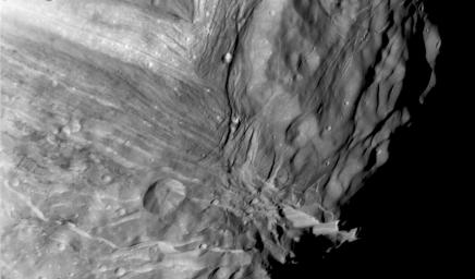
Miranda, innermost of Uranus' large satellites, is seen at close range in this Voyager 2 image, taken Jan. 24, 1986, as part of a high-resolution mosaicing sequence. Voyager was some 36,000 kilometers (22,000 miles) away from Miranda. This clear-filter, narrow-angle image shows an area about 250 km (150 mi) across, at a resolution of about 800 meters (2,600 feet). Two distinct terrain types are visible: a rugged, higher-elevation terrain (right) and a lower, striated terrain. Numerous craters on the rugged, higher terrain indicate that it is older than the lower terrain. Several scarps, probably faults, cut the different terrains. The impact crater in the lower part of this image is about 25 km (15 mi) across.
Background Info:
The Voyager project is managed for NASA by the Jet Propulsion Laboratory.
Cataloging Keywords:
| Name | Value | Additional Values |
|---|---|---|
| Target | Miranda | |
| System | Uranus | |
| Target Type | Satellite | |
| Mission | Voyager | |
| Instrument Host | Cassini Orbiter | Voyager 2 |
| Host Type | Orbiter | Flyby Spacecraft |
| Instrument | Imaging Science Subsystem (ISS) | |
| Detector | Narrow Angle Camera | |
| Extra Keywords | Crater, Grayscale, Impact, Visual | |
| Acquisition Date | ||
| Release Date | 1998-11-13 | |
| Date in Caption | 1986-01-24 | |
| Image Credit | NASA/JPL | |
| Source | photojournal.jpl.nasa.gov/catalog/PIA01354 | |
| Identifier | PIA01354 | |
