|
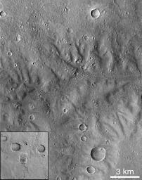
Dissected Terrain Near Parana Valles
- Click the image above for a larger view
- Full-Res JPEG (1023 x 1300) (293.4 kB)
- Full-Res TIFF (1023 x 1300) (1.4 MB)
Caption:
Portion of dissected terrain southeast of Parana Valles (MOC 7705). This heavily gullied landscape (25.9°S, 8.3°W) shows the highest "drainage density" yet seen in MOC images. This image is somewhat lower in resolution (downtrack scale = 21.4 m/pixel, crosstrack = 14.3 m/pixel) but in other parameters comparable to Figures 1 and 2 (incidence angle = 27.5°, emission angle = 14.5°).
Background Info:
Malin Space Science Systems and the California Institute of Technology built the MOC using spare hardware from the Mars Observer mission. MSSS operates the camera from its facilities in San Diego, CA. The Jet Propulsion Laboratory's Mars Surveyor Operations Project operates the Mars Global Surveyor spacecraft with its industrial partner, Lockheed Martin Astronautics, from facilities in Pasadena, CA and Denver, CO.
Cataloging Keywords:
| Name | Value | Additional Values |
|---|---|---|
| Target | Mars | |
| System | ||
| Target Type | Planet | |
| Mission | Mars Global Surveyor (MGS) | |
| Instrument Host | Mars Global Surveyor | |
| Host Type | Orbiter | |
| Instrument | Mars Orbiter Camera (MOC) | |
| Detector | ||
| Extra Keywords | Dust, Grayscale | |
| Acquisition Date | ||
| Release Date | 1999-02-19 | |
| Date in Caption | ||
| Image Credit | NASA/JPL/Malin Space Science Systems | |
| Source | photojournal.jpl.nasa.gov/catalog/PIA01507 | |
| Identifier | PIA01507 | |
