skip to navigation

|
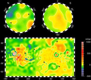
Mars Gravity Map (RS)
- Click the image above for a larger view
- Full-Res JPEG (2871 x 2520) (618.1 kB)
- Full-Res TIFF (2871 x 2520) (4.6 MB)
Caption:
Vertical gravity map of Mars color-coded in mgals based on radio tracking. Note correlations and lack of correlations with the global topography.
Cataloging Keywords:
| Name | Value | Additional Values |
|---|---|---|
| Target | Mars | |
| System | ||
| Target Type | Planet | |
| Mission | Mars Global Surveyor (MGS) | |
| Instrument Host | Mars Global Surveyor | |
| Host Type | Orbiter | |
| Instrument | Imaging Radar | |
| Detector | ||
| Extra Keywords | Color, Map, Radio | |
| Acquisition Date | ||
| Release Date | 1999-06-23 | |
| Date in Caption | ||
| Image Credit | NASA/JPL/GSFC | |
| Source | photojournal.jpl.nasa.gov/catalog/PIA02054 | |
| Identifier | PIA02054 | |
