|
Smooth Volcanic Plains
- Click the image above for a larger view
- Full-Res JPEG (356 x 311) (25.9 kB)
- Full-Res TIFF (356 x 311) (111.1 kB)
Caption:
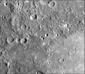
The plains filling this 440 kilometer basin centered at 15 degrees S, 149 degrees W (partially shown in the lower right of the picture) are uniformly brighter and slightly redder than the surrounding cratered terrain [Hapke et al., 1975]. Also, notice the flooded craters on the floor of the basin and that the terrain exterior to the basin is much more heavily cratered than the plains on the interior. These relationships indicate the smooth plains filling this basin are volcanic.
This image (FDS 125) was taken during the spacecraft's first encounter with Mercury.
Background Info:
The Mariner 10 mission, managed by the Jet Propulsion Laboratory for NASA's Office of Space Science, explored Venus in February 1974 on the way to three encounters with Mercury-in March and September 1974 and in March 1975. The spacecraft took more than 7,000 photos of Mercury, Venus, the Earth and the Moon.
Cataloging Keywords:
| Name | Value | Additional Values |
|---|---|---|
| Target | Mercury | |
| System | ||
| Target Type | Planet | |
| Mission | Mariner | |
| Instrument Host | Mariner 10 | |
| Host Type | Flyby Spacecraft | |
| Instrument | ||
| Detector | ||
| Extra Keywords | Crater, Grayscale, Moon, Volcano | |
| Acquisition Date | ||
| Release Date | 2000-01-18 | |
| Date in Caption | ||
| Image Credit | NASA/JPL/Northwestern University | |
| Source | photojournal.jpl.nasa.gov/catalog/PIA02443 | |
| Identifier | PIA02443 | |
