skip to navigation

|
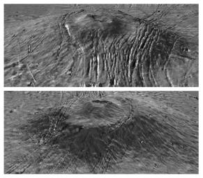
Major Martian Volcanoes from MOLA - Alba Patera
- Click the image above for a larger view
- Full-Res JPEG (524 x 462) (52.9 kB)
- Full-Res TIFF (524 x 462) (239.9 kB)
Caption:
Two views of Alba Patera with topography draped over a Viking image mosaic. MOLA data have clarified the relationship between fault location and topography on and surrounding the Alba construct, providing insight into the volcanological and geophysical processes that shaped the edifice. The vertical exaggeration is 10:1.
Cataloging Keywords:
| Name | Value | Additional Values |
|---|---|---|
| Target | Mars | |
| System | ||
| Target Type | Planet | |
| Mission | Mars Global Surveyor (MGS) | Viking |
| Instrument Host | Mars Global Surveyor | |
| Host Type | Orbiter | |
| Instrument | Mars Orbiter Laser Altimeter (MOLA) | |
| Detector | ||
| Extra Keywords | Grayscale, Volcano | |
| Acquisition Date | ||
| Release Date | 2000-09-07 | |
| Date in Caption | ||
| Image Credit | NASA/MOLA Science Team | |
| Source | photojournal.jpl.nasa.gov/catalog/PIA02803 | |
| Identifier | PIA02803 | |
