skip to navigation

|
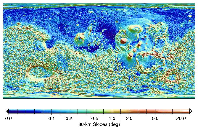
MOLA Global Map of Surface Gradients on Mars
- Click the image above for a larger view
- Full-Res JPEG (669 x 441) (128.2 kB)
- Full-Res TIFF (669 x 441) (254.8 kB)
Caption:
Absolute slopes on 30-km baselines indicate the magnitude of typical regional tilts of that scale. The Northern hemisphere is flatter than the South, and shows some linear slope breaks, for example north of Alba Patera (40N, 250E) and the Tharsis province. The major volcanos display flanks slopes of 2.5-5 degrees, comparable to Hawaiian shields. The southwest rim of the Hellas impact basin appears relatively eroded, with shallower typical slopes. A shaded relief map of the topography is overlaid is monochrome.
Cataloging Keywords:
| Name | Value | Additional Values |
|---|---|---|
| Target | Mars | |
| System | ||
| Target Type | Planet | |
| Mission | Mars Global Surveyor (MGS) | |
| Instrument Host | Mars Global Surveyor | |
| Host Type | Orbiter | |
| Instrument | Mars Orbiter Laser Altimeter (MOLA) | |
| Detector | ||
| Extra Keywords | Color, Impact, Map, Volcano | |
| Acquisition Date | ||
| Release Date | 2000-10-06 | |
| Date in Caption | ||
| Image Credit | NASA/JPL/GSFC | |
| Source | photojournal.jpl.nasa.gov/catalog/PIA02809 | |
| Identifier | PIA02809 | |