skip to navigation

|
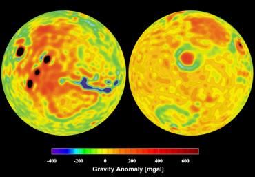
Mars Gravity Anomoly Map
- Click the image above for a larger view
- Full-Res JPEG (4000 x 2769) (619.8 kB)
- Full-Res TIFF (4000 x 2769) (16.6 MB)
Caption:
This is a vertical gravity map of Mars color-coded in mgals based on radio tracking. Note correlations and lack of correlations with the Mars Orbiter Laser Altimeter (MOLA) global topography.
This map was created using MGS data under the direction of Bill Sjogren, a member of the MGS Radio Science Team. The Radio Science Team is led by G. Leonard Tyler of Stanford University in Palo Alto, CA.
Cataloging Keywords:
| Name | Value | Additional Values |
|---|---|---|
| Target | Mars | |
| System | ||
| Target Type | Planet | |
| Mission | Mars Global Surveyor (MGS) | |
| Instrument Host | Mars Global Surveyor | |
| Host Type | Orbiter | |
| Instrument | ||
| Detector | ||
| Extra Keywords | Color, Map, Radio | |
| Acquisition Date | ||
| Release Date | 2001-01-17 | |
| Date in Caption | ||
| Image Credit | NASA/JPL | |
| Source | photojournal.jpl.nasa.gov/catalog/PIA02817 | |
| Identifier | PIA02817 | |
