|
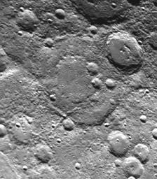
Large Double-ringed Basin
- Click the image above for a larger view
- Full-Res JPEG (311 x 356) (34.1 kB)
- Full-Res TIFF (311 x 356) (117.7 kB)
Caption:
Taken about 40 minutes before Mariner 10 made its close approach to Mercury on September 21, this picture (FDS 166684) shows a large (230 kilometers, 142 miles) double-ringed basin (center of picture) located in the planet's south polar region - 75 degrees S. Lat. 120 degrees W. Long. Mercury saw the basin from a different viewing angle on Mariner 10's first sweep last March. This picture was taken from about 55,000 kilometers (44,000 miles). North is toward upper left.
Background Info:
The Mariner 10 mission, managed by the Jet Propulsion Laboratory for NASA's Office of Space Science, explored Venus in February 1974 on the way to three encounters with Mercury-in March and September 1974 and in March 1975. The spacecraft took more than 7,000 photos of Mercury, Venus, the Earth and the Moon.
Cataloging Keywords:
| Name | Value | Additional Values |
|---|---|---|
| Target | Mercury | |
| System | ||
| Target Type | Planet | |
| Mission | Mariner | |
| Instrument Host | Mariner 10 | |
| Host Type | Flyby Spacecraft | |
| Instrument | ||
| Detector | ||
| Extra Keywords | Grayscale, Moon | |
| Acquisition Date | ||
| Release Date | 2000-08-05 | |
| Date in Caption | ||
| Image Credit | NASA/JPL/Northwestern University | |
| Source | photojournal.jpl.nasa.gov/catalog/PIA02942 | |
| Identifier | PIA02942 | |
