Naktong Valles
Caption:

(Released 04 April 2002)
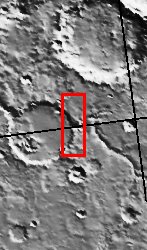
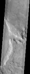
This image is located in a cratered highland region called Arabia Terra. The center right side of the image shows a branch of the valley network Naktong Vallis cutting into the eastern rim of an unnamed crater. A simple sequence of geologic events can be ascertained from this image. Early on in time this surface was subjected to bombardment from asteroids and comets thereby creating the pockmarked highlands. This was followed by channel incision into the former rim of the large crater seen near the center of this image. The last series of events to occur in this image are primarily aeolian (wind) related. These include the dark streaks seen on slopes. Numerous dark streaks coursing down the slopes of crater and channel walls suggests that the relatively bright dust which mantles the slopes slides downhill and either exposes a dust-free darker surface or creates a darker surface by increasing its roughness.
Cataloging Keywords:
| Name |
Value |
Additional Values |
| Target |
Mars |
|
| System |
|
|
| Target Type |
Planet |
|
| Mission |
2001 Mars Odyssey |
|
| Instrument Host |
Mars Odyssey |
|
| Host Type |
Orbiter |
|
| Instrument |
Thermal Emission Imaging System (THEMIS) |
|
| Detector |
|
|
| Extra Keywords |
Crater, Dust, Grayscale |
| Acquisition Date |
|
| Release Date |
2002-05-21 |
| Date in Caption |
2002-04-04 |
|
| Image Credit |
NASA/JPL/Arizona State University |
| Source |
photojournal.jpl.nasa.gov/catalog/PIA03762 |
| Identifier |
PIA03762 |


