Coprates Chasma
Caption:
(Released 21 May 2002)
The Science
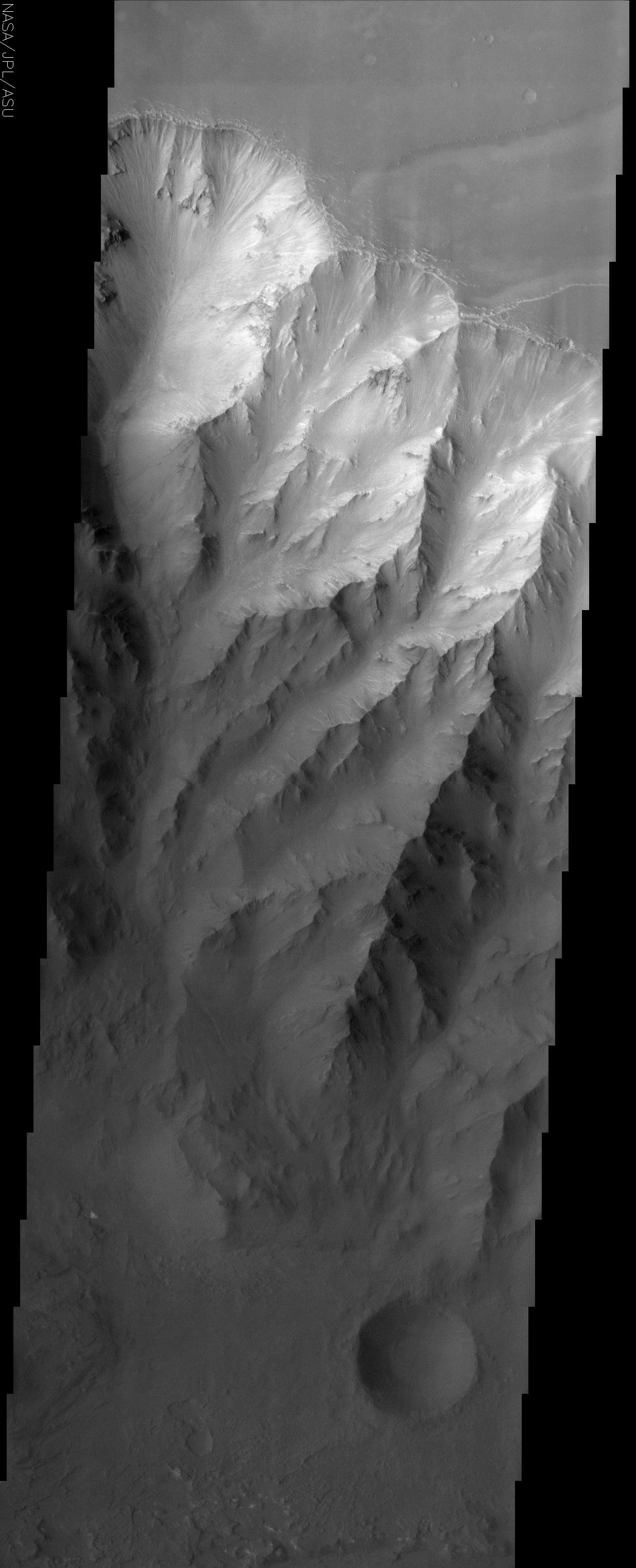
This THEMIS visible image shows the northern interior wall of Coprates Chasma, one of the major canyons that form Valles Marineris. The cliff face seen in this image drops over 8 km from the plateau of Ophir Planum to the north (top) to the floor of Coprates. A complex set of ridges and chutes has been eroded into the layered rock that forms the canyon walls. Streamers of bright and dark material can be seen in many of the chutes, suggesting that loose material (sediment) is moving down the chutes toward the canyon floor. In many places this sediment has completely buried the wall. The uppermost layers near the rim of the canyon are brighter than the lower layers, suggesting that the upper layers are composed of different materials than occur further down the wall. Very few small impact craters can be seen in this image, indicating that the erosion and transport of material down the canyon wall and across the floor is occurring at a relatively rapid rate, so that any craters that form are rapidly buried or eroded.
The Story
From the smooth plateau of Ophir Planum (top of image), the dramatic canyon wall of Coprates Chasma falls in chutes and ridges for almost five miles to the dark floor of the canyon, where one lone, brooding impact crater can be seen. It is a rare sight in this part of the canyon, because all of the erosion on the cliff face happens so fast that most craters are rapidly buried or eroded.
You can see how looser material is transported down the canyon by observing all of the bright and dark streaks streaming down the wall. A particularly good example of this continuing descent is in the left-most canyon shoot, where material has tumbled down into its center crevice, gathering in a pile about mid-way down (left-hand side of the image, right at the point where the bright material meets the dark).
A canyon like this one is kind of like a slice through the geologic history of the planet. Each layer in the rock formed at different times, with different materials. You can tell that the bright material in this image is made of different rocks and minerals than the darker layers toward the bottom.
If a lander or a rover ever went to study a Martian canyon up close, a good place to land would be at the bottom. That's because all of the rock and soil from the top layers are carried down to the bottom. Without needing to climb up the steep canyon wall for a closer look, scientific instruments on the lander or rover would be able to study all the different kinds of materials right there at the bottom and determine what kinds of rock and soil formed through the ages.
Coprates Chasma is one of the major canyons that form Valles Marineris, the largest canyon system in the solar system. If Valles Marineris were on Earth, it would stretch all the way from California to Washington, D.C. Since it also slices a few miles down into the planet's interior, it's the perfect place to study the geological history of Mars.
Cataloging Keywords:
| Name |
Value |
Additional Values |
| Target |
Mars |
|
| System |
|
|
| Target Type |
Planet |
|
| Mission |
2001 Mars Odyssey |
Mariner |
| Instrument Host |
Mars Odyssey |
|
| Host Type |
Orbiter |
Flyby Spacecraft |
| Instrument |
Thermal Emission Imaging System (THEMIS) |
|
| Detector |
|
|
| Extra Keywords |
Crater, Grayscale, Impact, Rotation |
| Acquisition Date |
|
| Release Date |
2002-06-17 |
| Date in Caption |
2002-05-21 |
|
| Image Credit |
NASA/JPL/Arizona State University |
| Source |
photojournal.jpl.nasa.gov/catalog/PIA03809 |
| Identifier |
PIA03809 |
