Maunder Crater
Caption:
(Released 24 May 2002)
The Science
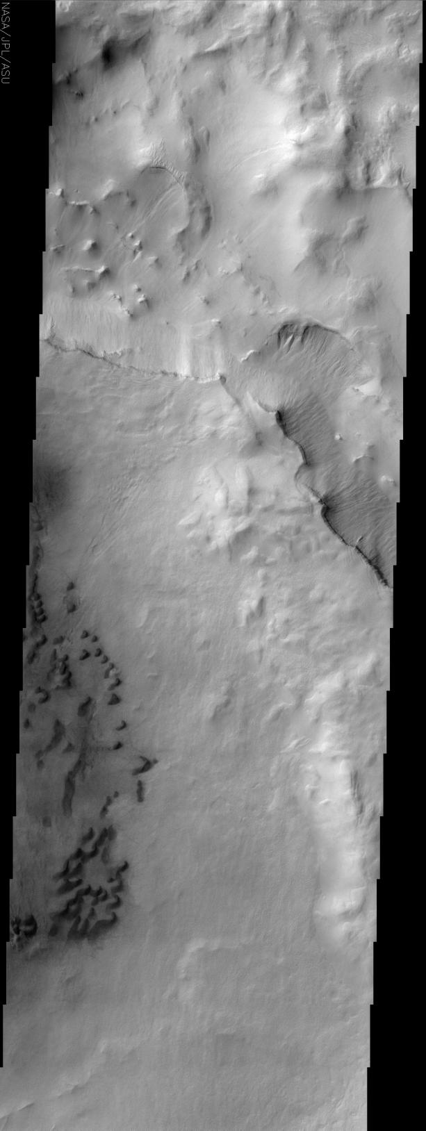
This image is of a portion of Maunder Crater located at about 49 S and 358 W (2 E). There are a number of interesting features in this image. The lower left portion of the image shows a series of barchan dunes that are traveling from right to left. The sand does not always form dunes as can be seen in the dark and diffuse areas surrounding the dune field. The other interesting item in this image are the gullies that can be seen streaming down from just beneath a number of sharp ridgelines in the upper portion of the image. These gullies were first seen by the MOC camera on the MGS spacecraft and it is though that they formed by groundwater leaking out of the rock layers on the walls of craters. The water runs down the slope and forms the fluvial features seen in the image. Other researchers think that these features could be formed by other fluids, such as CO
2
. These features are typically seen on south facing slopes in the southern hemisphere, though this image has gullies on north facing slopes as well.
The Story
Little black squigglies seem to worm their way down the left-hand side of this image. These land features are called barchan (crescent-shaped) dunes. Barchan dunes are found in sandy deserts on Earth, so it's no surprise the Martian wind makes them a common site on the red planet too. They were first named by a Russian scientist named Alexander von Middendorf, who studied the inland desert dunes of Turkistan.
The barchan dunes in this image occur in the basin of Maunder crater on Mars, and are traveling from right to left. The sand does not always form dunes, though, as can be seen in the dark areas of scattered sand surrounding the dune field.
Look for the streaming gullies that appear just beneath a number of sharp ridgelines in the upper portion of the image. These gullies were first discovered by the Mars Orbital Camera on the Mars Global Surveyor spacecraft. While most crater gullies are found on south-facing slopes in the southern hemisphere of Mars, you can see from this image that they occur on north-facing slopes as well. Comparing where gullies appear will help scientists understand more about the conditions under which they form.
Some researchers are really excited about gullies on Mars, because they believe these surface tracings might be signs that groundwater has leaked out of the rock layers on the walls of craters. If that's true, the water runs down the slope and forms the flow-like features seen in the image.
Scientists can get into some really hot debates, however. Other researchers think that these features could be formed by other fluids, such as carbon dioxide. No one knows for sure, so a lot of heads will be studiously bent over these images, continuing to study them closely. The neat thing about science is that the way you get closer to the truth is to hypothesize and then test, test, and test again. Debate for scientists is seen as an essential means of making sure that no wrong assumptions are made or that no important factor is left out. It's what keeps the field interesting and dynamic . . . and sometimes quite loud and entertaining!
Cataloging Keywords:
| Name |
Value |
Additional Values |
| Target |
Mars |
|
| System |
|
|
| Target Type |
Planet |
|
| Mission |
2001 Mars Odyssey |
Mars Global Surveyor (MGS) |
| Instrument Host |
Mars Odyssey |
Mars Global Surveyor |
| Host Type |
Orbiter |
|
| Instrument |
Thermal Emission Imaging System (THEMIS) |
Mars Orbiter Camera (MOC) |
| Detector |
|
|
| Extra Keywords |
Crater, Dune, Grayscale, Water |
| Acquisition Date |
|
| Release Date |
2002-06-17 |
| Date in Caption |
2002-05-24 |
|
| Image Credit |
NASA/JPL/Arizona State University |
| Source |
photojournal.jpl.nasa.gov/catalog/PIA03812 |
| Identifier |
PIA03812 |