|
Odyssey/ Becquerel
- Click the image above for a larger view
- Full-Res JPEG (1740 x 1176) (317.0 kB)
- Full-Res TIFF (1740 x 1176) (1.9 MB)
Caption:
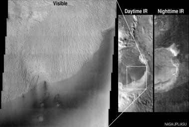
These images from Mars Odyssey look at the Becquerel crater in different lights -- visible, daytime infrared and nighttime infrared. The daytime images (left and center) were acquired on March 28, 2002 and the nighttime image (right) was acquired on March 2, 2002, by the thermal emission imaging system aboard Mars Odyssey. Thermal infrared is the wavelength range associated with heat. Looking at the Martian surface in the infrared wavelengths allows scientists to identify and distinguish bedrock from sand or dust covered areas.
The Becquerel deposit is relatively bright in the visible wavelengths. Its surface has been scoured by windblown sand to produce the ridged topography seen in the visible image, which spans an 18-kilometer (11 mile)-wide portion of the deposit. Dark sand is seen in the lower right of the visible image. This same scene in the 32-kilometer (20 mile)-wide daytime infrared image looks remarkably similar to a photographic negative of the visible image due to the effects of solar heating. Darker tones represent cooler surfaces, brighter tones are warmer ones. During the day, visibly dark surfaces heat up much more efficiently than bright surfaces. The relatively bright sediments of the mound reflect more solar energy than the darker sand, allowing the mound to stay cooler than the sand.
In the nighttime infrared image, the mound and the sand are warmer than their surroundings. The dark portions of the image represent cold surfaces that are covered in dust particles. Dust does not retain heat during the cold Martian night and quickly gives up any heat received during the day. Sand particles, because they are larger than dust particles, are able to retain heat better, producing the brighter swath around the mound. The infrared image has a resolution of 100 meters (328 feet) per pixel and is 32 kilometers (20 miles) wide. The visible image has a resolution of 18 meters per pixel and is approximately 18 kilometers (11 miles) wide. The images are centered at 21.4 degrees north latitude and 351.8 degrees east longitude.
Background Info:
NASA's Jet Propulsion Laboratory manages the 2001 Mars Odyssey mission for NASA's Office of Space Science, Washington, D.C. The Thermal Emission Imaging System was developed by Arizona State University, Tempe, in collaboration with Raytheon Santa Barbara Remote Sensing. Lockheed Martin Astronautics, Denver, is the prime contractor for the Odyssey project, and developed and built the orbiter. Mission operations are conducted jointly from Lockheed Martin and from JPL, a division of the California Institute of Technology in Pasadena.
Cataloging Keywords:
| Name | Value | Additional Values |
|---|---|---|
| Target | Mars | |
| System | ||
| Target Type | Planet | |
| Mission | 2001 Mars Odyssey | |
| Instrument Host | Mars Odyssey | |
| Host Type | Orbiter | |
| Instrument | Thermal Emission Imaging System (THEMIS) | |
| Detector | ||
| Extra Keywords | Crater, Dust, Grayscale, Infrared, Thermal | |
| Acquisition Date | ||
| Release Date | 2002-10-01 | |
| Date in Caption | 2002-03-02 | 2002-03-28 |
| Image Credit | NASA/JPL/Arizona State University | |
| Source | photojournal.jpl.nasa.gov/catalog/PIA03863 | |
| Identifier | PIA03863 | |
