skip to navigation
|
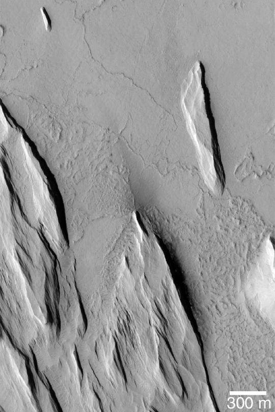
Yardangs and Exhumation
- Click the image above for a larger view
- Full-Res JPEG (540 x 810) (66.5 kB)
- Full-Res TIFF (540 x 810) (438.1 kB)
Caption:
MGS MOC Release No. MOC2-359, 13 May 2003
This Mars Global Surveyor (MGS) Mars Orbiter Camera (MOC) image shows the results of wind erosion of a thick deposit of fine-grained, cemented material. The ridges oriented roughly from upper left to lower right (northwest to southeast) are called yardangs . Similar features occur in some of Earth's desert regions. The flat surface with narrow, sinuous ridges at the top (north) end of the picture is interpreted to be an ancient lava plain that is being slowly revealed as the overlying materials are eroded away. This picture is located near 13.2°N, 159.9°W. Sunlight illuminates the scene from the left/lower left.
Cataloging Keywords:
| Name | Value | Additional Values |
|---|---|---|
| Target | Mars | |
| System | ||
| Target Type | Planet | |
| Mission | Mars Global Surveyor (MGS) | |
| Instrument Host | Mars Global Surveyor | |
| Host Type | Orbiter | |
| Instrument | Mars Orbiter Camera (MOC) | |
| Detector | ||
| Extra Keywords | Grayscale | |
| Acquisition Date | ||
| Release Date | 2003-05-14 | |
| Date in Caption | 2003-05-13 | |
| Image Credit | NASA/JPL/Malin Space Science Systems | |
| Source | photojournal.jpl.nasa.gov/catalog/PIA04518 | |
| Identifier | PIA04518 | |