|
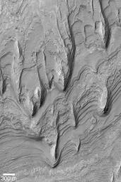
Gale Sedimentary Rocks
- Click the image above for a larger view
- Full-Res JPEG (540 x 810) (96.6 kB)
- Full-Res TIFF (540 x 810) (438.1 kB)
Caption:
MGS MOC Release No. MOC2-439, 1 August 2003
Gale Crater, located in the Aeolis region near 5.5°S, 222°W, contains a mound of layered sedimentary rock that stands higher than the rim of the crater. This giant mound suggests that the entire crater was not only once filled with sediment, it was also buried beneath sediment. This Mars Global Surveyor (MGS) Mars Orbiter Camera (MOC) image shows some of the eroded remains of the sedimentary rock that once filled Gale Crater. The layers form terraces; wind has eroded the material to form the tapered, pointed yardang ridges seen here. The small circular feature in the lower right quarter of the picture is a mesa that was once a small meteor impact crater that was filled, buried, then exhumed from within the sedimentary rock layers exposed here. This image is illuminated from the left.
Cataloging Keywords:
| Name | Value | Additional Values |
|---|---|---|
| Target | Mars | |
| System | ||
| Target Type | Planet | |
| Mission | Mars Global Surveyor (MGS) | |
| Instrument Host | Mars Global Surveyor | |
| Host Type | Orbiter | |
| Instrument | Mars Orbiter Camera (MOC) | |
| Detector | ||
| Extra Keywords | Crater, Grayscale, Impact | |
| Acquisition Date | ||
| Release Date | 2003-08-01 | |
| Date in Caption | 2003-08-01 | |
| Image Credit | NASA/JPL/Malin Space Science Systems | |
| Source | photojournal.jpl.nasa.gov/catalog/PIA04672 | |
| Identifier | PIA04672 | |
