|
Defrosting South Polar Slope
- Click the image above for a larger view
- Full-Res JPEG (851 x 1277) (180.9 kB)
- Full-Res TIFF (851 x 1277) (1.1 MB)
Caption:
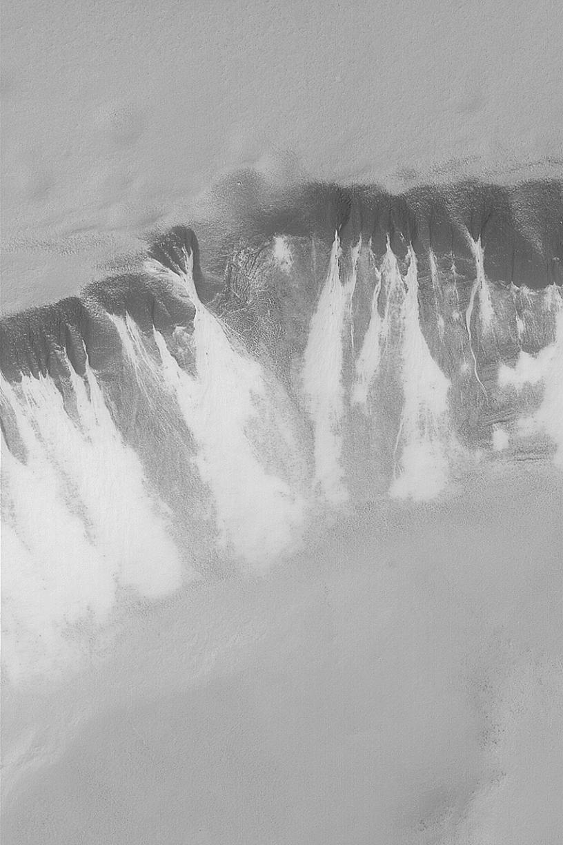
MGS MOC Release No. MOC2-467, 29 August 2003
Today, August 29, 2003, Mars Global Surveyor (MGS) completes its 20,000th orbit since the start of the mapping phase of the mission in March 1999. Each of the 20,000 nearly-polar, nearly-circular orbits around the planet takes about 2 hours. The spacecraft passes over each martian polar region twelve times a day. This July 2003 MGS Mars Orbiter Camera (MOC) image shows defrosting gullies and mass movement (landslide) features in the south polar region. This is a springtime view; all of the carbon dioxide and water ice that accumulated on the ground during the previous winter is subliming away. The different physical properties of the ground beneath the frost lead to differences in the length of time that a particular surface retains frost as spring progresses. Here, the areas that still have the most frost are the bright features associated with gullies and landslide deposits. These deposits may contain more sand than their surrounding terrain--we know from images of martian sand dunes that frost tends to linger a bit later in the spring on a sandy surface. This image is located near 70.7°S, 358.2°W. The slope bearing gullies and landslide materials is facing toward the bottom/lower right. Sunlight illuminates the scene from the lower right. This image covers an area 3 km (1.9 mi) wide.
Cataloging Keywords:
| Name | Value | Additional Values |
|---|---|---|
| Target | Mars | |
| System | ||
| Target Type | Planet | |
| Mission | Mars Global Surveyor (MGS) | |
| Instrument Host | Mars Global Surveyor | |
| Host Type | Orbiter | |
| Instrument | Mars Orbiter Camera (MOC) | |
| Detector | ||
| Extra Keywords | Dune, Grayscale, Water | |
| Acquisition Date | ||
| Release Date | 2003-09-05 | |
| Date in Caption | 2003-08-29 | |
| Image Credit | NASA/JPL/Malin Space Science Systems | |
| Source | photojournal.jpl.nasa.gov/catalog/PIA04719 | |
| Identifier | PIA04719 | |