skip to navigation

|
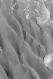
Dark Sand Dunes
- Click the image above for a larger view
- Full-Res JPEG (674 x 1011) (55.4 kB)
- Full-Res TIFF (674 x 1011) (655.3 kB)
Caption:
MGS MOC Release No. MOC2-509, 10 October 2003
This April 2003 Mars Global Surveyor (MGS) Mars Orbiter Camera (MOC) image shows dark sand dunes in a crater north of Syrtis Major near 27.1°N, 297.2°W. The steepest slopes on each dune face toward the bottom/lower left of the image, indicating that the dominant winds that influenced their formation came from the north (the top of the image). Layers are exposed in a butte at the lower right corner of the picture; this butte is a remnant of layered rock that once covered the entire crater floor on which the dunes occur. This picture covers an area 3 km (1.9 mi) wide and is illuminated by sunlight from the lower left.
Cataloging Keywords:
| Name | Value | Additional Values |
|---|---|---|
| Target | Mars | |
| System | ||
| Target Type | Planet | |
| Mission | Mars Global Surveyor (MGS) | |
| Instrument Host | Mars Global Surveyor | |
| Host Type | Orbiter | |
| Instrument | Mars Orbiter Camera (MOC) | |
| Detector | ||
| Extra Keywords | Crater, Dune, Grayscale | |
| Acquisition Date | ||
| Release Date | 2003-10-14 | |
| Date in Caption | 2003-10-10 | |
| Image Credit | NASA/JPL/Malin Space Science Systems | |
| Source | photojournal.jpl.nasa.gov/catalog/PIA04791 | |
| Identifier | PIA04791 | |
