skip to navigation

|
Right on Target
- Click the image above for a larger view
- Full-Res JPEG (720 x 540) (41.8 kB)
- Full-Res TIFF (720 x 540) (337.8 kB)
Caption:
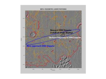
This map shows the estimated location of the Mars Exploration Rover Spirit within Gusev Crater, Mars. Engineers targeted Spirit for the center of the blue ellipse. Measurements taken during the rover's descent by the Deep Space Network predicted its landing site to be the spot marked with a black dot. Later measurements taken on the ground by both the Deep Space Network and the orbiter Mars Odyssey narrowed the predicted landing site to a spot marked with a white dot. When initially choosing a landing site for the rover, engineers avoided hazardous terrain outlined here in yellow and red. This map consists of data from Mars Odyssey and Mars Global Surveyor.
Cataloging Keywords:
| Name | Value | Additional Values |
|---|---|---|
| Target | Mars | |
| System | ||
| Target Type | Planet | |
| Mission | 2001 Mars Odyssey | Deep Space Network (DSN), Mars Exploration Rover (MER), Mars Global Surveyor (MGS) |
| Instrument Host | Mars Odyssey | Mars Global Surveyor, Spirit (MER-A) |
| Host Type | Orbiter | Rover |
| Instrument | Mars Orbiter Camera (MOC) | Thermal Emission Imaging System (THEMIS) |
| Detector | ||
| Extra Keywords | Color, Crater, Map, Radio | |
| Acquisition Date | ||
| Release Date | 2004-01-13 | |
| Date in Caption | ||
| Image Credit | NASA/JPL/Arizona State University | |
| Source | photojournal.jpl.nasa.gov/catalog/PIA05055 | |
| Identifier | PIA05055 | |
