skip to navigation

|
Found You!
- Click the image above for a larger view
- Full-Res JPEG (1000 x 750) (101.3 kB)
- Full-Res TIFF (1000 x 750) (768.7 kB)
Caption:
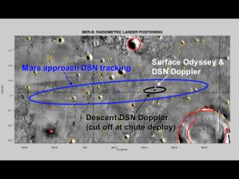
This map of the Mars Exploration Rover Opportunity's new neighborhood at Meridiani Planum, Mars, demonstrates how engineers honed in on the location of the rover. The larger blue ellipse shows the projected landing area just before arriving at Mars. The black ellipse denotes the first approximation of the rover's location after landing based on radio signals received by NASA's Deep Space Network during entry, descent and landing. The white cross points to the rover's precise location based on radio signals sent from the surface both directly to Earth through the Deep Space Network and through NASA's Mars Odyssey orbiter.
Cataloging Keywords:
| Name | Value | Additional Values |
|---|---|---|
| Target | Mars | |
| System | ||
| Target Type | Planet | |
| Mission | 2001 Mars Odyssey | Deep Space Network (DSN), Mars Exploration Rover (MER) |
| Instrument Host | Mars Odyssey | Opportunity (MER-B) |
| Host Type | Orbiter | Rover |
| Instrument | ||
| Detector | ||
| Extra Keywords | Color, Map, Radio | |
| Acquisition Date | ||
| Release Date | 2004-02-09 | |
| Date in Caption | ||
| Image Credit | NASA/JPL/MSSS/ASU | |
| Source | photojournal.jpl.nasa.gov/catalog/PIA05224 | |
| Identifier | PIA05224 | |
