skip to navigation

|
Becquerel Beckons
- Click the image above for a larger view
- Full-Res JPEG (836 x 1781) (233.6 kB)
- Full-Res TIFF (836 x 1781) (1.5 MB)
Caption:
15 February 2004
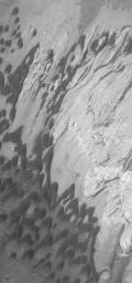
Calling out across millions of miles of space, the compelling dark sand dunes and light-toned sedimentary rock outcrops of Becquerel Crater and dozens of other layered rock sites on Mars beg for further scientific investigation. Layered rocks record the history of a place; the younger layers are above the older ones. This Mars Global Surveyor (MGS) Mars Orbiter Camera (MOC) image shows some of the dunes and layered rocks in Becquerel, a ~170 km (~106 mi) wide crater in western Arabia Terra. Wind has blown the dunes toward the southwest (lower left). The image is located near 21.5°N, 8.6°W. Sunlight illuminates the scene from the lower left; the image covers an area 3 km (1.9 mi) wide.
Cataloging Keywords:
| Name | Value | Additional Values |
|---|---|---|
| Target | Mars | |
| System | ||
| Target Type | Planet | |
| Mission | Mars Global Surveyor (MGS) | |
| Instrument Host | Mars Global Surveyor | |
| Host Type | Orbiter | |
| Instrument | Mars Orbiter Camera (MOC) | |
| Detector | ||
| Extra Keywords | Crater, Dune, Grayscale | |
| Acquisition Date | ||
| Release Date | 2004-02-15 | |
| Date in Caption | 2004-02-15 | |
| Image Credit | NASA/JPL/Malin Space Science Systems | |
| Source | photojournal.jpl.nasa.gov/catalog/PIA05297 | |
| Identifier | PIA05297 | |
