skip to navigation

|
King of the Crater Ledge
- Click the image above for a larger view
- Full-Res JPEG (800 x 800) (88.6 kB)
- Full-Res TIFF (800 x 800) (970.2 kB)
Caption:
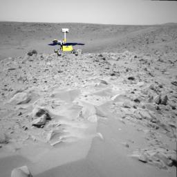
This image shows a screenshot from software used by engineers to drive the Mars Exploration Rover Spirit up toward the rim of the crater dubbed "Bonneville." The software simulates the rover's movements across the martian terrain, helping to plot a safe course. The virtual 3-D world around the rover is built from images taken by Spirit's stereo navigation cameras. Regions for which the rover has not yet acquired 3-D data are represented in beige.
In this picture, the rover is seen in its projected final position at the rim of the crater. Later today, Spirit will travel 16 more meters (52 feet) to reach the crater ledge.
Cataloging Keywords:
| Name | Value | Additional Values |
|---|---|---|
| Target | Mars | |
| System | ||
| Target Type | Planet | |
| Mission | Mars Exploration Rover (MER) | |
| Instrument Host | Spirit (MER-A) | |
| Host Type | Rover | |
| Instrument | Navigation Camera (Navcam) | |
| Detector | ||
| Extra Keywords | Color, Crater | |
| Acquisition Date | ||
| Release Date | 2004-03-11 | |
| Date in Caption | ||
| Image Credit | NASA/JPL | |
| Source | photojournal.jpl.nasa.gov/catalog/PIA05544 | |
| Identifier | PIA05544 | |
