
|
MSIP: Multinational Research in Memnonia Fossae
- Click the image above for a larger view
- Full-Res JPEG (1327 x 3080) (325.9 kB)
- Full-Res TIFF (1327 x 3080) (2.9 MB)
Caption:
Released 21 April 2004
Our group is from Saratoga Springs, NY and is called the Saratoga Springs NASA Club. It contains approximately 30 students between 9th and 12th grade who have been participating since September of 2001. We also worked with a small group of students from Chekhov, Russia in order to do a joint MSIP project. Chekhov is the sister city of Saratoga Springs. Their group contains kids of the same age group as our NASA Club. Our group, along with a few students from the Chekhov branch, visited Arizona State University in November of 2003.
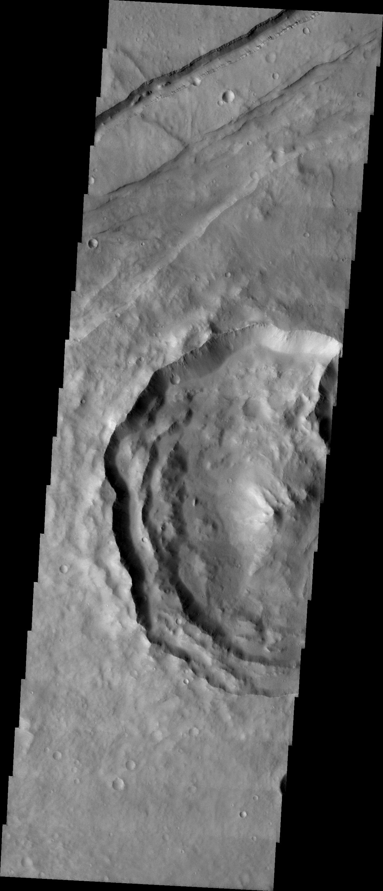
We targeted our image in the Memnonia Fossae Region because our thesis had to do with the relationship between craters with lobates and the depth of the craters as use for evidence of the presence of water in the past. Our Russian counter parts agreed with this idea because they wanted to look into the relationship between gully formation and whether or not it could hint at the presence of water on Mars.
The major feature of our image is a large crater that contains lobates situated on the mid-left hand side of the image. Other features present in the image include a graben running along the top section and a channel that runs parallel to it. We are still looking into the possibilities behind the structure of the crater and if it could have had something to do with the presence of water on the surface. This area is somewhat unique due to its relative closeness to a region containing three of the largest volcanoes in the solar system. We believe that the graben could be due to volcanic activity in the past that affected our area.
Image information: VIS instrument. Latitude -2.7°, Longitude 217.2° East (142.8%deg; West). 19 meter/pixel resolution.
Note: this THEMIS visual image has not been radiometrically nor geometrically calibrated for this preliminary release. An empirical correction has been performed to remove instrumental effects. A linear shift has been applied in the cross-track and down-track direction to approximate spacecraft and planetary motion. Fully calibrated and geometrically projected images will be released through the Planetary Data System in accordance with Project policies at a later time.
Background Info:
NASA and Arizona State University's Mars Education Program is offering students nationwide the opportunity to be involved in authentic Mars research by participating in the Mars Student Imaging Project (MSIP). Teams of students in grades 5 through college sophomore level have the opportunity to work with scientists, mission planners and educators on the THEMIS team at ASU's Mars Space Flight Facility, to image a site on Mars using the THEMIS visible wavelength camera. For more information go to the MSIP website: http://msip.asu.edu .
NASA's Jet Propulsion Laboratory manages the 2001 Mars Odyssey mission for NASA's Office of Space Science, Washington, D.C. The Thermal Emission Imaging System (THEMIS) was developed by Arizona State University, Tempe, in collaboration with Raytheon Santa Barbara Remote Sensing. The THEMIS investigation is led by Dr. Philip Christensen at Arizona State University. Lockheed Martin Astronautics, Denver, is the prime contractor for the Odyssey project, and developed and built the orbiter. Mission operations are conducted jointly from Lockheed Martin and from JPL, a division of the California Institute of Technology in Pasadena.
Cataloging Keywords:
| Name | Value | Additional Values |
|---|---|---|
| Target | Mars | |
| System | ||
| Target Type | Planet | |
| Mission | 2001 Mars Odyssey | |
| Instrument Host | Mars Odyssey | |
| Host Type | Orbiter | |
| Instrument | Thermal Emission Imaging System (THEMIS) | |
| Detector | ||
| Extra Keywords | Crater, Grayscale, Thermal, Volcano, Water | |
| Acquisition Date | ||
| Release Date | 2004-04-21 | |
| Date in Caption | 2004-04-21 | |
| Image Credit | NASA/JPL/Arizona State University | |
| Source | photojournal.jpl.nasa.gov/catalog/PIA05800 | |
| Identifier | PIA05800 | |