North Polar Features
Caption:
28 November 2004
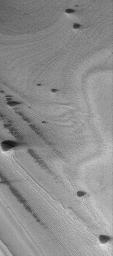
This Mars Global Surveyor (MGS) Mars Orbiter Camera (MOC) image shows banded terrain of the north polar region of Mars. The bands are exposures of layered material, possibly composed of dust and ice. The dark, rounded to elliptical mounds in this image might be the locations of ancient sand dunes that were completely buried in the north polar layered material. In more recent times, these mounds have been exhumed from within the layered material. Alternatively, the dark features are not ancient, exhumed dunes, but perhaps the remnants of a dark layer of material that once covered the entire area shown in the image. These features are located near 79.9°N, 31.4°W. The image covers an area about 3 km (1.9 mi) wide. Sunlight illuminates the scene from the lower left.
Cataloging Keywords:
| Name |
Value |
Additional Values |
| Target |
Mars |
|
| System |
|
|
| Target Type |
Planet |
|
| Mission |
Mars Global Surveyor (MGS) |
|
| Instrument Host |
Mars Global Surveyor |
|
| Host Type |
Orbiter |
|
| Instrument |
Mars Orbiter Camera (MOC) |
|
| Detector |
|
|
| Extra Keywords |
Dune, Dust, Grayscale |
| Acquisition Date |
|
| Release Date |
2004-11-28 |
| Date in Caption |
2004-11-28 |
|
| Image Credit |
NASA/JPL/Malin Space Science Systems |
| Source |
photojournal.jpl.nasa.gov/catalog/PIA07093 |
| Identifier |
PIA07093 |

