skip to navigation

|
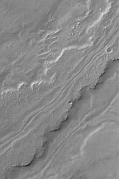
Leveed Channel in Lava Flow
- Click the image above for a larger view
- Full-Res JPEG (512 x 768) (77.4 kB)
- Full-Res TIFF (512 x 768) (393.8 kB)
Caption:
14 December 2004
This Mars Global Surveyor (MGS) Mars Orbiter Camera (MOC) image shows a leveed channel running down the middle of a lava flow in Daedalia Planum, the southern plains of the Tharsis volcanic region. Transport of fluid lava through a channel such as this helps insulate the molten rock, keeping it hot longer, and thus permits the flow to extend to greater distances than it otherwise might. This example is located near 23.6°S, 123.2°W, and covers an area approximately 3 km (1.9 mi) wide. The scene is illuminated by sunlight from the upper left.
Cataloging Keywords:
| Name | Value | Additional Values |
|---|---|---|
| Target | Mars | |
| System | ||
| Target Type | Planet | |
| Mission | Mars Global Surveyor (MGS) | |
| Instrument Host | Mars Global Surveyor | |
| Host Type | Orbiter | |
| Instrument | Mars Orbiter Camera (MOC) | |
| Detector | ||
| Extra Keywords | Grayscale, Volcano | |
| Acquisition Date | ||
| Release Date | 2004-12-14 | |
| Date in Caption | 2004-12-14 | |
| Image Credit | NASA/JPL/Malin Space Science Systems | |
| Source | photojournal.jpl.nasa.gov/catalog/PIA07129 | |
| Identifier | PIA07129 | |
