Meridiani Craters
Caption:
26 December 2004
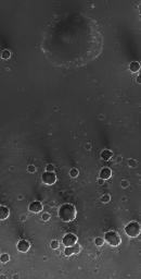
A little over 11 months ago, the Mars Exploration Rover, Opportunity, landed on Meridiani Planum. This Mars Global Surveyor (MGS) Mars Orbiter Camera (MOC) image shows a small portion of Meridiani Planum -- too far from the rover for it to investigate--that has been peppered with small impact craters. The majority of craters, particularly those in the lower half of the image, are secondary impacts caused by the landing of rock and debris ejected from a much larger impact crater, located elsewhere in the region. The large, nearly circular depression at the top center of the image is the site of a much older crater that was filled and almost completely buried beneath the plains. As result of the rover's work in Meridiani Planum, it is now known that the bright rims and walls of the craters are, at least in part, exposures of sedimentary rock. The dark material covering the plains, according to rover results, is mostly very fine sand plus millimeter-sized granules. This picture covers an area about 3 km (1.9 mi) across, and is located near 2.5°S, 3.3°W. Sunlight illuminates the scene from the left.
Cataloging Keywords:
| Name |
Value |
Additional Values |
| Target |
Mars |
|
| System |
|
|
| Target Type |
Planet |
|
| Mission |
Mars Global Surveyor (MGS) |
Mars Exploration Rover (MER) |
| Instrument Host |
Mars Global Surveyor |
Opportunity (MER-B) |
| Host Type |
Orbiter |
Rover |
| Instrument |
Mars Orbiter Camera (MOC) |
|
| Detector |
|
|
| Extra Keywords |
Crater, Grayscale, Impact |
| Acquisition Date |
|
| Release Date |
2004-12-26 |
| Date in Caption |
2004-12-26 |
|
| Image Credit |
NASA/JPL/Malin Space Science Systems |
| Source |
photojournal.jpl.nasa.gov/catalog/PIA07151 |
| Identifier |
PIA07151 |

