|
MOC 1000th Release!
- Click the image above for a larger view
- Full-Res JPEG (640 x 1020) (152.1 kB)
- Full-Res TIFF (640 x 1020) (653.7 kB)
Caption:
12 February 2005
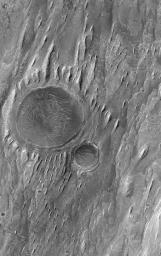
This Mars Global Surveyor (MGS) Mars Orbiter Camera (MOC) image shows the remains of two impact craters that were filled, buried, and then exhumed from within layered sedimentary rock in the martian crater, Gale. Wind erosion has sculpted tapered yardang ridges in the uppermost rock layers exposed at this location.
This is the 1000th captioned image release from the MGS MOC team. The first release occurred in July 1997, when the spacecraft was still speeding toward the red planet. Many people have asked "why are the releases numbered starting with 'MOC2'?" The MGS MOC is the second MOC, so it is designated "MOC2." The first MOC was flown on the Mars Observer spacecraft, which was lost just before arrival at Mars in August 1993. The MOC science investigation was originally selected by NASA in 1986. The MGS MOC effort is currently in its third extended mission, and is funded through at least October 2006.
Location near
: 5.0°S, 222.8°W
Image width
: ~3.0 km (~1.9 mi)
Illumination from
: upper left
Season
: Southern Winter
Cataloging Keywords:
| Name | Value | Additional Values |
|---|---|---|
| Target | Mars | |
| System | ||
| Target Type | Planet | |
| Mission | Mars Global Surveyor (MGS) | |
| Instrument Host | Mars Global Surveyor | |
| Host Type | Orbiter | |
| Instrument | Mars Orbiter Camera (MOC) | |
| Detector | ||
| Extra Keywords | Crater, Grayscale, Impact | |
| Acquisition Date | ||
| Release Date | 2005-02-12 | |
| Date in Caption | 2005-02-12 | |
| Image Credit | NASA/JPL/Malin Space Science Systems | |
| Source | photojournal.jpl.nasa.gov/catalog/PIA07353 | |
| Identifier | PIA07353 | |
