skip to navigation

|
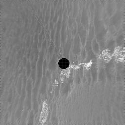
Beside ‘Vostok Crater’ (vertical)
- Click the image above for a larger view
- Full-Res JPEG (4000 x 4000) (1.0 MB)
- Full-Res TIFF (4000 x 4000) (10.3 MB)
Caption:
NASA's Mars Exploration Rover Opportunity used its navigation camera to take the images combined into this 360-degree view of the rover's surroundings on the 399th martian day, or sol, of its surface mission (March 8, 2005). Opportunity drove 35 meters (115 feet) that sol and reached the edge of "Vostok Crater" before taking the images. Sand has buried much of the crater. This location is catalogued as Opportunity's site 50. The view is presented in a vertical projection with geometric seam correction.
Cataloging Keywords:
| Name | Value | Additional Values |
|---|---|---|
| Target | Mars | |
| System | ||
| Target Type | Planet | |
| Mission | Mars Exploration Rover (MER) | |
| Instrument Host | Opportunity (MER-B) | |
| Host Type | Rover | |
| Instrument | Navigation Camera (Navcam) | |
| Detector | ||
| Extra Keywords | Crater, Grayscale | |
| Acquisition Date | ||
| Release Date | 2005-03-17 | |
| Date in Caption | 2005-03-08 | |
| Image Credit | NASA/JPL | |
| Source | photojournal.jpl.nasa.gov/catalog/PIA07471 | |
| Identifier | PIA07471 | |
