skip to navigation

|
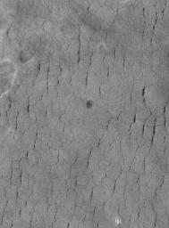
Polygons in Utopia
- Click the image above for a larger view
- Full-Res JPEG (1024 x 1386) (230.3 kB)
- Full-Res TIFF (1024 x 1386) (1.4 MB)
Caption:
14 April 2005
This Mars Global Surveyor (MGS) Mars Orbiter Camera (MOC) image shows a typical view of polygon-cracked and pitted surfaces unique to western Utopia Planitia. No other place on Mars has this appearance. Some Mars scientists have speculated that ground ice may be responsible for these landforms.
Location near
: 42.3°N, 275.6°W
Image width
: ~3 km (~1.9 mi)
Illumination from
: lower left
Season
: Northern Summer
Cataloging Keywords:
| Name | Value | Additional Values |
|---|---|---|
| Target | Mars | |
| System | ||
| Target Type | Planet | |
| Mission | Mars Global Surveyor (MGS) | |
| Instrument Host | Mars Global Surveyor | |
| Host Type | Orbiter | |
| Instrument | Mars Orbiter Camera (MOC) | |
| Detector | ||
| Extra Keywords | Grayscale | |
| Acquisition Date | ||
| Release Date | 2005-04-14 | |
| Date in Caption | 2005-04-14 | |
| Image Credit | NASA/JPL/Malin Space Science Systems | |
| Source | photojournal.jpl.nasa.gov/catalog/PIA07839 | |
| Identifier | PIA07839 | |
