skip to navigation

|
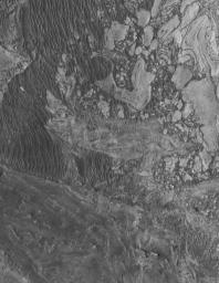
Broken Sedimentary Rocks
- Click the image above for a larger view
- Full-Res JPEG (2048 x 2652) (793.7 kB)
- Full-Res TIFF (2048 x 2652) (5.4 MB)
Caption:
18 May 2005
This Mars Global Surveyor (MGS) Mars Orbiter Camera (MOC) image shows broken-up blocks of sedimentary rock in western Candor Chasma. There are several locations in western Candor that exhibit this pattern of broken rock. The manner in which these landforms were created is unknown; it is possible that there was a landslide or a meteoritic impact that broke up the materials. One attribute that is known: in some of these cases, it seems that the rock was broken and then buried by later sedimentary rocks, before later being exhumed so that they can be seen from orbit today.
Location near
: 6.9°S, 75.5°W
Image width
: ~3 km (~1.9 mi)
Illumination from
: upper left
Season
: Southern Winter
Cataloging Keywords:
| Name | Value | Additional Values |
|---|---|---|
| Target | Mars | |
| System | ||
| Target Type | Planet | |
| Mission | Mars Global Surveyor (MGS) | |
| Instrument Host | Mars Global Surveyor | |
| Host Type | Orbiter | |
| Instrument | Mars Orbiter Camera (MOC) | |
| Detector | ||
| Extra Keywords | Grayscale, Impact | |
| Acquisition Date | ||
| Release Date | 2005-05-18 | |
| Date in Caption | 2005-05-18 | |
| Image Credit | NASA/JPL/Malin Space Science Systems | |
| Source | photojournal.jpl.nasa.gov/catalog/PIA07951 | |
| Identifier | PIA07951 | |
