|
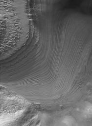
Galle Bedding
- Click the image above for a larger view
- Full-Res JPEG (1290 x 1754) (571.5 kB)
- Full-Res TIFF (1290 x 1754) (2.3 MB)
Caption:
15 June 2006
Galle Crater
, not to be confused with the equatorial
Gale Crater
, is also known as "
Happy Face Crater
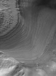
." A mound of layered rock -- in places over-ridden by dark sand dunes -- occurs immediately south of the "mouth" of Happy Face Crater. The mosaic of Mars Global Surveyor (MGS) Mars Orbiter Camera (MOC) narrow angle images shown here reveals some of the details of a portion of the mound not covered by dunes. Groups of layers in the lowermost portion of this exposure cut across each other in several places. Each of these cross-cutting relations indicates a period during which the deposition of these layered materials -- interpreted to be sediment -- stopped and erosion took place instead. These periods of erosion were followed by new sedimentation -- new deposition of granular material. Unknown is whether these layers represent sediments deposited by wind or water; the cross bedding is reminiscent of the patterns of sand deposition in windblown dunes, but these features are larger than the textures and patterns commonly found in sand dunes. The picture is a mosaic of three MOC images, E22-01557, M14-02055, and R11-04138, each taken in a different martian year and at a different time of the year. The annotated figure (right) shows the location of a dust devil that was observed in the summertime image, R11-04138.
Location near
: 52.3°S, 30.1°W
Image width
: ~4 km (~2.5 mi)
Illumination from
: upper left
Mosaic of MOC images
: E22-01557, M14-02055, R11-04138
Cataloging Keywords:
| Name | Value | Additional Values |
|---|---|---|
| Target | Mars | |
| System | ||
| Target Type | Planet | |
| Mission | Mars Global Surveyor (MGS) | |
| Instrument Host | Mars Global Surveyor | |
| Host Type | Orbiter | |
| Instrument | Mars Orbiter Camera (MOC) | |
| Detector | ||
| Extra Keywords | Crater, Dune, Dust, Grayscale, Water | |
| Acquisition Date | ||
| Release Date | 2006-06-15 | |
| Date in Caption | 2006-06-15 | |
| Image Credit | NASA/JPL/Malin Space Science Systems | |
| Source | photojournal.jpl.nasa.gov/catalog/PIA08544 | |
| Identifier | PIA08544 | |

