|
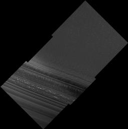
North Polar Layered Deposits in Summer
- Click the image above for a larger view
- Full-Res JPEG (13469 x 13491) (8.9 MB)
- Full-Res TIFF (13469 x 13491) (181.7 MB)
Caption:
The High Resolution Imaging Science Experiment (HiRISE) on NASA's Mars Reconnaissance Orbiter acquired this image during its first day of test imaging from the spacecraft's low-altitude mapping orbit, Sept. 29, 2006.
This image of Mars' north polar layered deposits was taken during the summer season (solar longitude of 113.6 degrees), when carbon dioxide frost had evaporated from the surface. The bright spots seen here are most likely patches of water frost, but the location of the frost patches does not appear to be controlled by topography. Layers are visible at the bottom of the image, mostly due to difference in slope between them. The variations in slope are probably caused by differences in the physical properties of the layers. Thinner layers that have previously been observed in these deposits are visible, and may represent annual deposition of water ice and dust that is thought to form the polar layered deposits. These deposits are thought to record global climate variations on Mars, similar to ice ages on Earth. HiRISE images such as this should allow Mars' climate record to be inferred and compared with climate changes on Earth.
Image TRA_000825_2665 was taken by the High Resolution Imaging Science Experiment (HiRISE) camera onboard the Mars Reconnaissance Orbiter spacecraft on September 29, 2006. Shown here is the full image, centered at 86.5 degree latitude, 172.0 degrees east longitude. The image is oriented such that north is to the top. The range to the target site was 298.9 kilometers (186.8 miles). At this distance the image scale is 59.8 centimeters (23.5 inches) per pixel (with two-by-two binning} so objects about 1.79 meters (70 inches) across are resolved. In total the original image was 12.2 kilometers 7.58 mile; 10024 pixels) wide and 6.1 kilometers (3.79 miles; 5000 pixels) long. The image was taken at a local Mars time of 3:30 PM and the scene is illuminated from the southwest with a solar incidence angle of 63.5 degrees, thus the sun was about 26.5 degrees above the horizon.
Background Info:
NASA's Jet Propulsion Laboratory, a division of the California Institute of Technology in Pasadena, manages the Mars Reconnaissance Orbiter for NASA's Science Mission Directorate, Washington. Lockheed Martin Space Systems is the prime contractor for the project and built the spacecraft. The HiRISE camera was built by Ball Aerospace Corporation and is operated by the University of Arizona.
Cataloging Keywords:
| Name | Value | Additional Values |
|---|---|---|
| Target | Mars | |
| System | ||
| Target Type | Planet | |
| Mission | Mars Reconnaissance Orbiter (MRO) | |
| Instrument Host | Mars Reconnaissance Orbiter | |
| Host Type | Orbiter | |
| Instrument | High Resolution Imaging Science Experiment (HiRISE) | |
| Detector | ||
| Extra Keywords | Dust, Grayscale, Water | |
| Acquisition Date | ||
| Release Date | 2006-09-30 | |
| Date in Caption | 2006-09-29 | |
| Image Credit | NASA/JPL/University of Arizona | |
| Source | photojournal.jpl.nasa.gov/catalog/PIA08791 | |
| Identifier | PIA08791 | |
