|
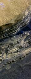
Layers Exposed at Polar Canyon
- Click the image above for a larger view
- Full-Res JPEG (4000 x 10119) (5.4 MB)
- Full-Res TIFF (4000 x 10119) (121.4 MB)
Caption:
This false-color subframe of an image from the High Resolution Imaging Science Experiment camera on NASA's Mars Reconnaissance Orbiter shows the north polar layered deposits at top and darker materials at bottom, exposed in a scarp at the head of Chasma Boreale, a large canyon eroded into the layered deposits.
The polar layered deposits appear red because of dust mixed within them, but are ice-rich as indicated by previous observations. Water ice in the layered deposits is probably responsible for the pattern of fractures seen near the top of the scarp. The darker material below the layered deposits may have been deposited as sand dunes, as indicated by the crossbedding (truncation of curved lines) seen near the middle of the scarp. It appears that brighter, ice-rich layers were deposited between the dark dunes in places. Exposures such as these are useful in understanding recent climate variations that are likely recorded in the polar layered deposits.
Background Info:
NASA's Jet Propulsion Laboratory, a division of the California Institute of Technology in Pasadena, manages the Mars Reconnaissance Orbiter for NASA's Science Mission Directorate, Washington. Lockheed Martin Space Systems, Denver, is the prime contractor for the project and built the spacecraft. The High Resolution Imaging Science Experiment is operated by the University of Arizona, Tucson, and the instrument was built by Ball Aerospace and Technology Corp., Boulder, Colo.
Cataloging Keywords:
| Name | Value | Additional Values |
|---|---|---|
| Target | Mars | |
| System | ||
| Target Type | Planet | |
| Mission | Mars Reconnaissance Orbiter (MRO) | |
| Instrument Host | Mars Reconnaissance Orbiter | |
| Host Type | Orbiter | |
| Instrument | High Resolution Imaging Science Experiment (HiRISE) | |
| Detector | ||
| Extra Keywords | Color, Dune, Dust, Water | |
| Acquisition Date | ||
| Release Date | 2006-12-13 | |
| Date in Caption | ||
| Image Credit | NASA/JPL-Caltech/Univ. of Arizona | |
| Source | photojournal.jpl.nasa.gov/catalog/PIA09097 | |
| Identifier | PIA09097 | |
