|
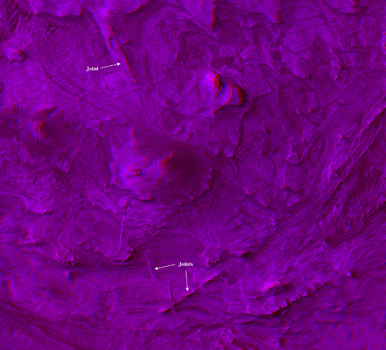
Ridges in Stereo, Candor Chasma
- Click the image above for a larger view
- Full-Res JPEG (480 x 1304) (54.8 kB)
- Full-Res TIFF (480 x 1304) (1.9 MB)
Caption:
A stereo view shows fractures called joints. They have a ridge-like shape, standing out in positive relief as the surrounding bedrock is eroded away faster than they are. This positive relief suggests that the rock along the joints has been strengthened through chemical reactions with fluids flowing through these joints.
The view appears three-dimensional when seen through red-green glasses. It combines two images taken by the High Resolution Imaging Science Experiment camera on NASA's Mars Reconnaissance Orbiter from slightly different overhead positions. The constituent blue image is a portion of image PSP_001641_1735 in the camera's catlog, taken Dec. 2, 2006. The red image is part of PSP_002063_1735, taken Jan. 4, 2007.
The area covered in this image is about 5.8 kilometers (3.6 miles) wide, located within Candor Chasma, approximately 60 kilometers (37 miles) southeast of the area shown in PIA09190 .
Background Info:
NASA's Jet Propulsion Laboratory, a division of the California Institute of Technology in Pasadena, manages the Mars Reconnaissance Orbiter for NASA's Science Mission Directorate, Washington. Lockheed Martin Space Systems, Denver, is the prime contractor for the project and built the spacecraft. The High Resolution Imaging Science Experiment is operated by the University of Arizona, Tucson, and the instrument was built by Ball Aerospace and Technology Corp., Boulder, Colo.
Cataloging Keywords:
| Name | Value | Additional Values |
|---|---|---|
| Target | Mars | |
| System | ||
| Target Type | Planet | |
| Mission | Mars Reconnaissance Orbiter (MRO) | |
| Instrument Host | Mars Reconnaissance Orbiter | |
| Host Type | Orbiter | |
| Instrument | High Resolution Imaging Science Experiment (HiRISE) | |
| Detector | ||
| Extra Keywords | Color | |
| Acquisition Date | ||
| Release Date | 2007-02-15 | |
| Date in Caption | 2006-12-02 | 2007-01-04 |
| Image Credit | NASA/JPL/Univ. of Arizona | |
| Source | photojournal.jpl.nasa.gov/catalog/PIA09192 | |
| Identifier | PIA09192 | |

