|
Rayed Gratteri Crater
- Click the image above for a larger view
- Full-Res JPEG (2048 x 3450) (783.0 kB)
- Full-Res TIFF (2048 x 3450) (7.1 MB)
Caption:
Click on image for larger version
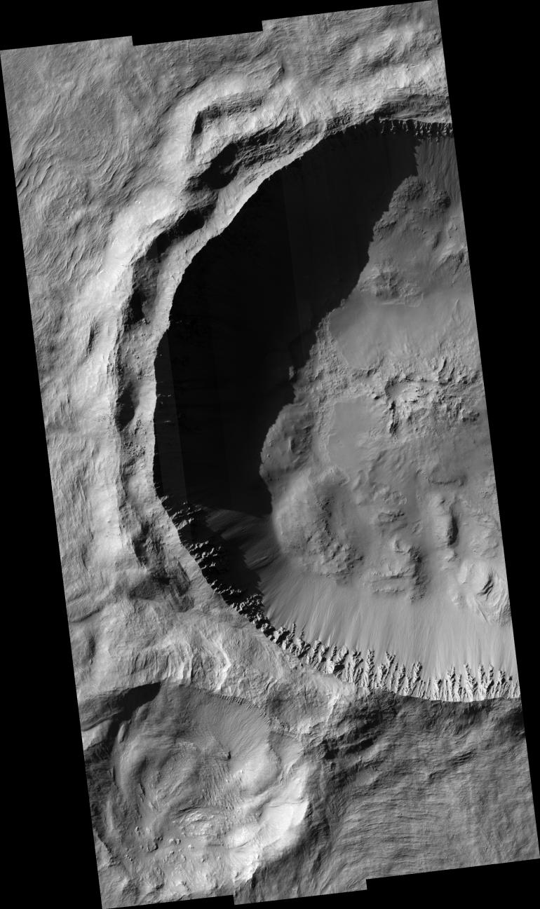
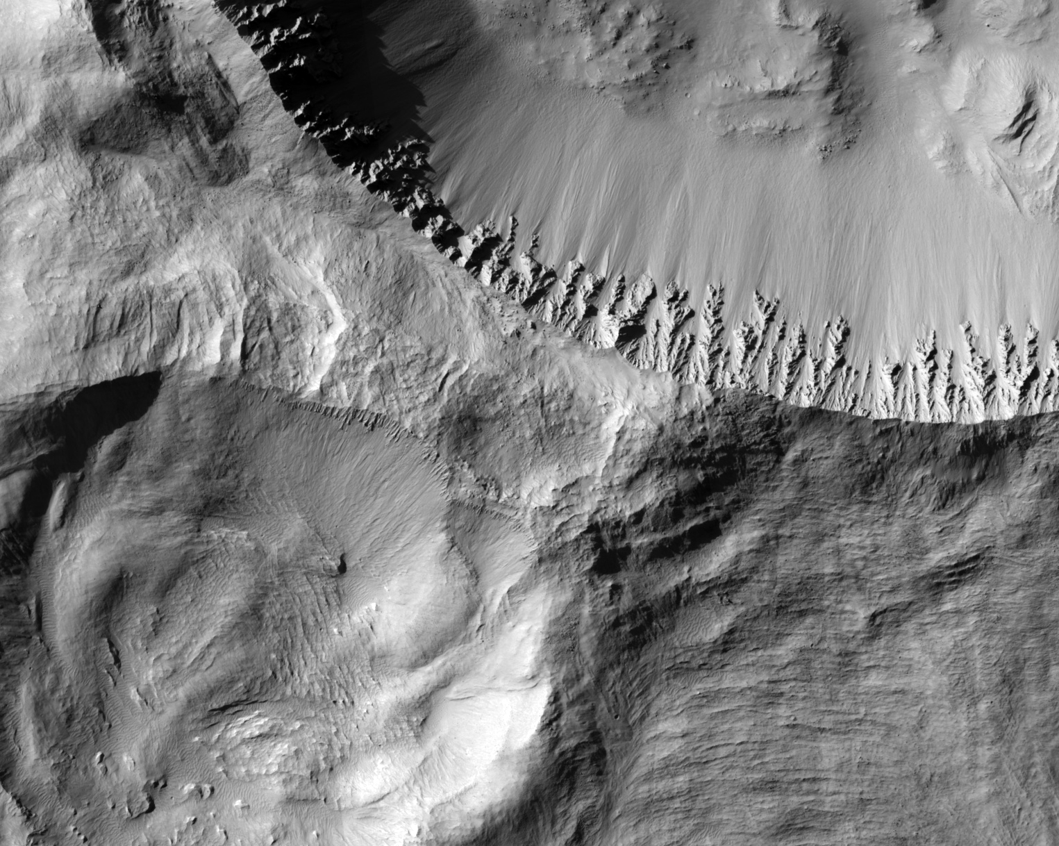
This HiRISE image covers the western portion of the primary cavity of Gratteri crater situated in the Memnonia Fossae region. Gratteri crater is one of five definitive large rayed craters on Mars. Gratteri crater has a diameter of approximately 6.9 kilometers. Crater rays are long, linear features formed from the high-velocity ejection of blocks of material that re-impact the surface in linear clusters or chains that appear to emanate from the main or primary cavity. Such craters have been long recognized as the "brightest" and "freshest" craters on the Moon. However, Martian rays differ from lunar rays in that they are not "bright," but best recognized by their thermal signature (at night) in 100 meter/pixel THEMIS thermal infrared images. The HiRISE image shows that Gratteri crater has well-developed and sharp crater morphologic features with no discernible superimposed impact craters. The HiRISE sub-image shows that this is true for the ejecta and crater floor up to the full resolution of the image. Massive slumped blocks of materials on the crater floor and the "spur and gully" morphology with the crater wall may suggest that the subsurface in this area may be thick and homogenous. Gratteri crater's ejecta blanket (as seen in THEMIS images) can be described as "fluidized," which may be suggestive of the presence of ground-ice that may have helped to "liquefy" the ejecta as it was deposited near the crater. Gratteri's ejecta can be observed to have flowed in and around obstacles including an older, degraded crater lying immediately to the SW of Gratteri's primary cavity.
Image PSP_001367_1620 was taken by the High Resolution Imaging Science Experiment (HiRISE) camera onboard the Mars Reconnaissance Orbiter spacecraft on November 10, 2006. The complete image is centered at -17.7 degrees latitude, 199.9 degrees East longitude. The range to the target site was 257.1 km (160.7 miles). At this distance the image scale ranges from 25.7 cm/pixel (with 1 x 1 binning) to 102.9 cm/pixel (with 4 x 4 binning). The image shown here has been map-projected to 25 cm/pixel and north is up. The image was taken at a local Mars time of 3:33 PM and the scene is illuminated from the west with a solar incidence angle of 64 degrees, thus the sun was about 26 degrees above the horizon. At a solar longitude of 133.6 degrees, the season on Mars is Northern Summer.
Background Info:
NASA's Jet Propulsion Laboratory, a division of the California Institute of Technology in Pasadena, manages the Mars Reconnaissance Orbiter for NASA's Science Mission Directorate, Washington. Lockheed Martin Space Systems, Denver, is the prime contractor for the project and built the spacecraft. The High Resolution Imaging Science Experiment is operated by the University of Arizona, Tucson, and the instrument was built by Ball Aerospace and Technology Corp., Boulder, Colo.
Cataloging Keywords:
| Name | Value | Additional Values |
|---|---|---|
| Target | Mars | |
| System | ||
| Target Type | Planet | |
| Mission | Mars Reconnaissance Orbiter (MRO) | |
| Instrument Host | Mars Reconnaissance Orbiter | |
| Host Type | Orbiter | |
| Instrument | High Resolution Imaging Science Experiment (HiRISE) | |
| Detector | ||
| Extra Keywords | Crater, Grayscale, Impact, Infrared, Map, Moon, Thermal | |
| Acquisition Date | ||
| Release Date | 2006-11-29 | |
| Date in Caption | 2006-11-10 | |
| Image Credit | NASA/JPL/Univ. of Arizona | |
| Source | photojournal.jpl.nasa.gov/catalog/PIA09369 | |
| Identifier | PIA09369 | |