|
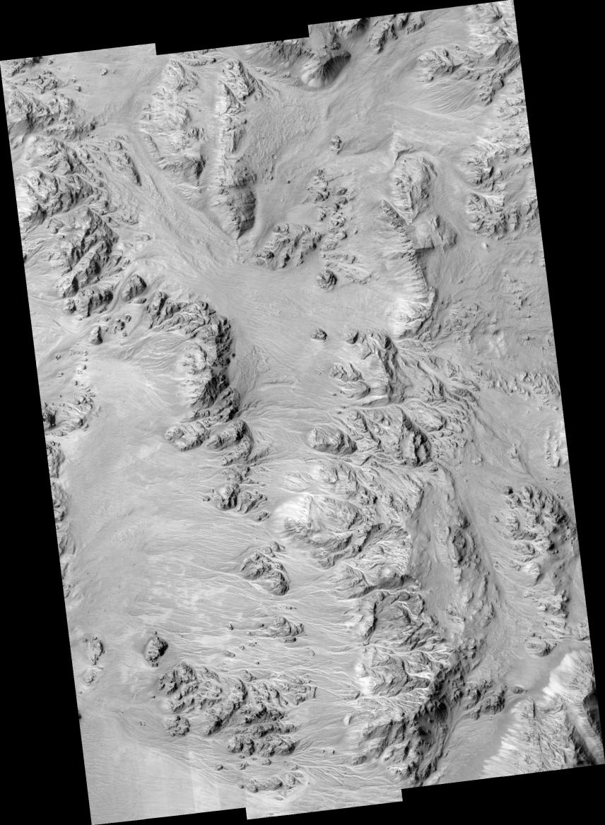
Alluvial Fans in Mojave Crater: Did It Rain on Mars?
- Click the image above for a larger view
- Full-Res JPEG (2048 x 2795) (731.5 kB)
- Full-Res TIFF (2048 x 2795) (5.7 MB)
Caption:
Click on image for larger version
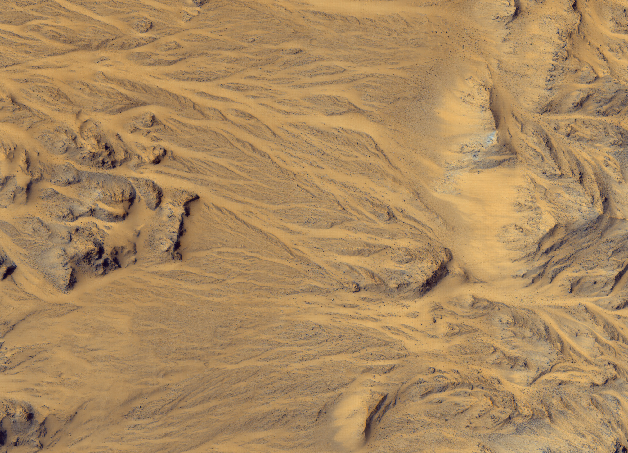
This HiRISE image at up to 29 cm/pixel scale supports the alluvial fan interpretation, in particular by showing that the sizes of the largest rocks decrease away from the mouths of the fans. Aptly-named Mojave crater in the Xanthe Terra region has alluvial fans that look remarkably similar to landforms in the Mojave Desert of southeastern California and portions of Nevada and Arizona. Alluvial fans are fan-shaped deposits of water-transported material (alluvium). They typically form at the base of hills or mountains where there is a marked break, or flattening of slope. They typically deposit big rocks near their mouths (close to the mountains) and smaller rocks at greater distances. Alluvial fans form as a result of heavy desert downpours, typically thundershowers. Because deserts are poorly vegetated, heavy and short-lived downpours create a great deal of erosion and nearby deposition. There are fans inside and around the outsides of Mojave crater on Mars that perfectly match the morphology of alluvial fans on Earth, with the exception of a few small impact craters dotting this Martian landscape. Channels begin at the apex of topographic ridges, consistent with precipitation as the source of water, rather than groundwater. This remarkable landscape was first discovered from Mars Orbital Camera images. Mars researchers have suggested that impact-induced atmospheric precipitation may have created these unique landscapes.
Image PSP_001415_1875 was taken by the High Resolution Imaging Science Experiment (HiRISE) camera onboard the Mars Reconnaissance Orbiter spacecraft on November 14, 2006. The complete image is centered at 7.6 degrees latitude, 327.4 degrees East longitude. The range to the target site was 273.5 km (170.9 miles). At this distance the image scale ranges from 27.4 cm/pixel (with 1 x 1 binning) to 109.4 cm/pixel (with 4 x 4 binning). The image shown here has been map-projected to 25 cm/pixel and north is up. The image was taken at a local Mars time of 3:29 PM and the scene is illuminated from the west with a solar incidence angle of 52 degrees, thus the sun was about 38 degrees above the horizon. At a solar longitude of 135.4 degrees, the season on Mars is Northern Summer.
Background Info:
NASA's Jet Propulsion Laboratory, a division of the California Institute of Technology in Pasadena, manages the Mars Reconnaissance Orbiter for NASA's Science Mission Directorate, Washington. Lockheed Martin Space Systems, Denver, is the prime contractor for the project and built the spacecraft. The High Resolution Imaging Science Experiment is operated by the University of Arizona, Tucson, and the instrument was built by Ball Aerospace and Technology Corp., Boulder, Colo.
Cataloging Keywords:
| Name | Value | Additional Values |
|---|---|---|
| Target | Mars | |
| System | ||
| Target Type | Planet | |
| Mission | Mars Reconnaissance Orbiter (MRO) | |
| Instrument Host | Mars Reconnaissance Orbiter | |
| Host Type | Orbiter | |
| Instrument | High Resolution Imaging Science Experiment (HiRISE) | |
| Detector | ||
| Extra Keywords | Atmosphere, Crater, Grayscale, Impact, Map, Mountain, Water | |
| Acquisition Date | ||
| Release Date | 2006-12-13 | |
| Date in Caption | 2006-11-14 | |
| Image Credit | NASA/JPL/Univ. of Arizona | |
| Source | photojournal.jpl.nasa.gov/catalog/PIA09399 | |
| Identifier | PIA09399 | |