|
Evidence of Multiple Episodes of Gully Formation
- Click the image above for a larger view
- Full-Res JPEG (2048 x 1922) (500.3 kB)
- Full-Res TIFF (2048 x 1922) (3.9 MB)
Caption:

Figure 1
Click on image for larger version
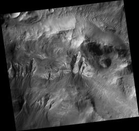
This HiRISE image ( PSP_001684_1410 ) shows gullies in a crater in Terra Sirenum. The gullies unusually emanate from different elevations along the crater wall. Several of the gullies are extremely developed and incised, while others have very narrow, shallow channels.
Many of the gullies appear to have extensive debris aprons, but that could be deceiving. Based on their surroundings, the topography underlying the debris aprons is likely not flat or gently sloping. This might cause the debris apron material to cover a wider surface area, without being as large of a volume as it might appear visually, than it otherwise would.
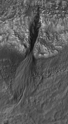
The subimage (figure 1) shows a gully with many channels. Several of the channels overlap or are overlapped by debris aprons suggesting that multiple flow episodes occurred here. In particular, there is a large channel that sticks out from underneath the main debris apron with a debris apron of its own. If this channel originated where the alcove currently is, then it is possible that the past flow contained more liquid and that the source of liquid to form the gullies in this region is now available in smaller amounts for an unknown reason.
Observation Geometry
Acquisition date:
12 December 2006
Local Mars time:
3:45 PM
Degrees latitude (centered):
-38.9 °
Degrees longitude (East):
196.0 °
Range to target site:
253.2 km (158.3 miles)
Original image scale range:
25.3 cm/pixel(with 1 x 1 binning) so objects ~76 cm across are resolved
Map-projected scale:
25 cm/pixel and north is up
Map-projection:
EQUIRECTANGULAR
Emission angle:
7.3 °
Phase angle:
69.1 °
Solar incidence angle:
74 °, with the Sun about 16 ° above the horizon
Solar longitude:
145.8 °, Northern Summer
Background Info:
NASA's Jet Propulsion Laboratory, a division of the California Institute of Technology in Pasadena, manages the Mars Reconnaissance Orbiter for NASA's Science Mission Directorate, Washington. Lockheed Martin Space Systems, Denver, is the prime contractor for the project and built the spacecraft. The High Resolution Imaging Science Experiment is operated by the University of Arizona, Tucson, and the instrument was built by Ball Aerospace and Technology Corp., Boulder, Colo.
Cataloging Keywords:
| Name | Value | Additional Values |
|---|---|---|
| Target | Mars | |
| System | ||
| Target Type | Planet | |
| Mission | Mars Reconnaissance Orbiter (MRO) | |
| Instrument Host | Mars Reconnaissance Orbiter | |
| Host Type | Orbiter | |
| Instrument | High Resolution Imaging Science Experiment (HiRISE) | |
| Detector | ||
| Extra Keywords | Crater, Grayscale, Infrared, Map | |
| Acquisition Date | ||
| Release Date | 2007-02-01 | |
| Date in Caption | 2006-12-12 | |
| Image Credit | NASA/JPL/Univ. of Arizona | |
| Source | photojournal.jpl.nasa.gov/catalog/PIA09582 | |
| Identifier | PIA09582 | |
