
|
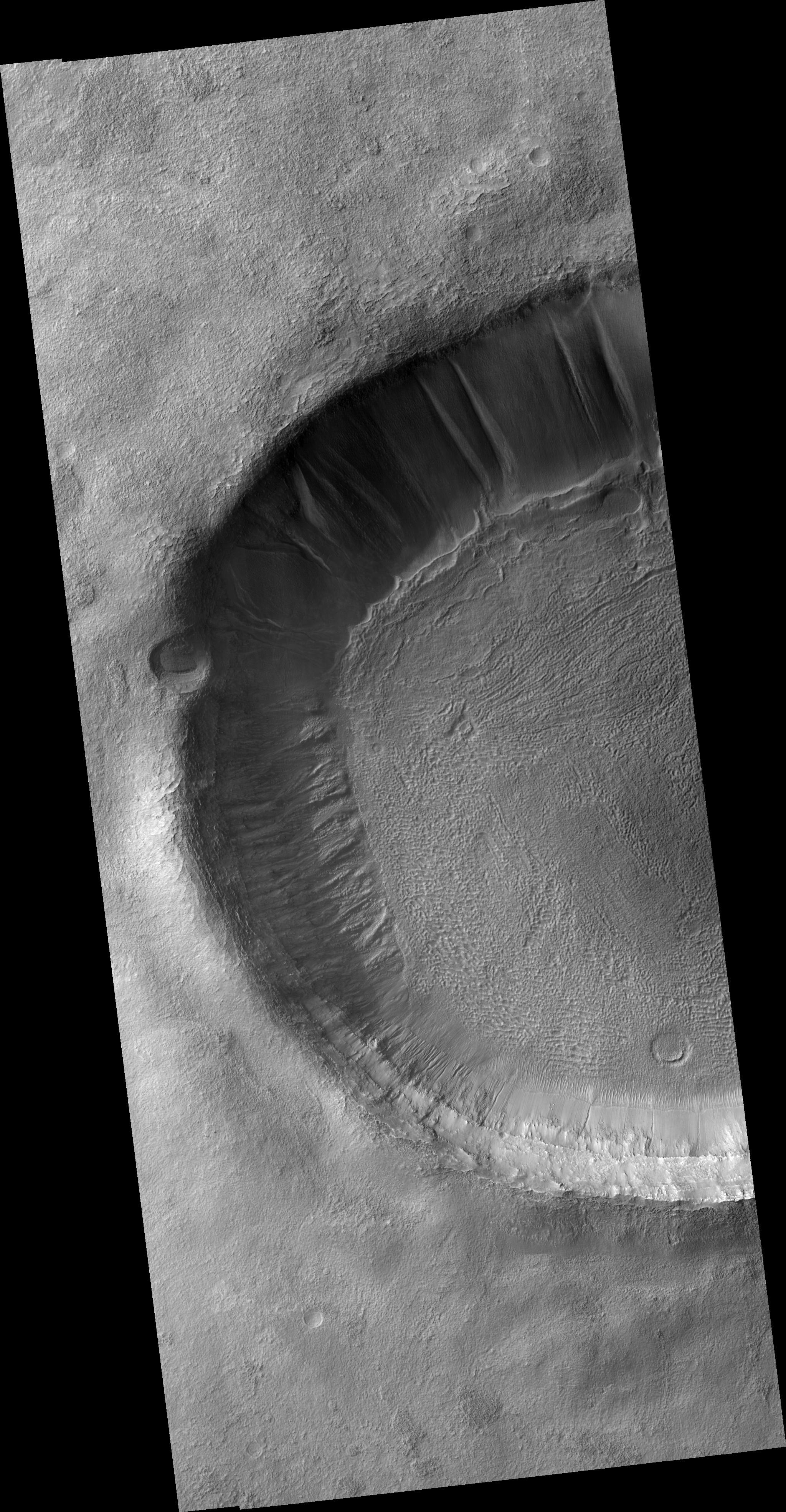
Scarp and Channels in a Crater in Terra Cimmeria
- Click the image above for a larger view
- Full-Res JPEG (2048 x 3938) (1.1 MB)
- Full-Res TIFF (2048 x 3938) (8.1 MB)
Caption:
Click on image for larger version
This HiRISE image ( PSP_001936_1370 ) shows a crater in Terra Cimmeria, approximately 10 km (6 miles) in diameter. The roughly concentric ridges and throughs in this crater's floor are known as "concentric crater fill," and probably result from compression caused by viscous flow of a thick mixture of rocks, soils, and ice inward from the crater's walls.
This and other examples of concentric crater fill (see ( PIA09662 ) occur at high latitudes, where theoretical calculations indicate that ice may exist under the surface, mixed with rocks and soil.
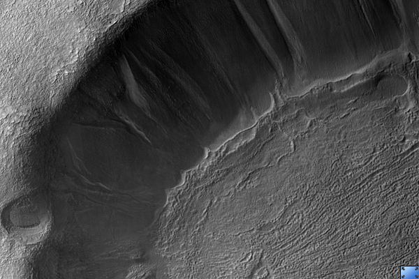
This image's cutout (180 x 560 m, or 200 x 600 yards) shows a small portion of the crater's north-looking wall; downhill is up, illumination is from the left. In the lower part of the cutout a relatively harder, rocky layer protrudes from the crater's wall; some blocks broke up from it and fell down the slope. Loose soils accumulated behind these blocks (uphill), forming what looks like bright-colored tails. The crater's floor, in the upper part of the cutout, is covered here by elongated dunes. A channel 7 to 20 m (7.5 to 22 yards) wide cuts deeply into the crater's wall; it is unclear if this channel was carved by a fluid or by landslides.
The channel is cut by a younger scarp (shown with yellow arrows pointing downhill) which approximately separates the crater's wall from its floor. This cliff can be followed for more than 3 km (2 miles) along the southern part of the crater's floor. Elsewhere in this image channels similar to the one shown here cut through (and, therefore, are younger than) the scarp, extending inside the crater's floor. This scarp may have been produced by settling of the crater's floor, maybe due to flow of ice, soil, and rocks towards the center of the crater, and/or to sublimation of underground ice.
Observation Toolbox
Acquisition date:
12 December 2006
Local Mars time:
3:47 PM
Degrees latitude (centered):
-42.7°
Degrees longitude (East):
158.5°
Range to target site:
251.6 km (157.3 miles)
Original image scale range:
from 25.2 cm/pixel (with 1 x 1 binning) to 50.3 cm/pixel (with 2 x 2 binning)
Map-projected scale:
25 cm/pixel and north is up
Map-projection:
EQUIRECTANGULAR
Emission angle:
2.4°
Phase angle:
72.3°
Solar incidence angle:
74°, with the Sun about 16° above the horizon
Solar longitude:
155.9°, Northern Summer
Background Info:
NASA's Jet Propulsion Laboratory, a division of the California Institute of Technology in Pasadena, manages the Mars Reconnaissance Orbiter for NASA's Science Mission Directorate, Washington. Lockheed Martin Space Systems, Denver, is the prime contractor for the project and built the spacecraft. The High Resolution Imaging Science Experiment is operated by the University of Arizona, Tucson, and the instrument was built by Ball Aerospace and Technology Corp., Boulder, Colo.
Cataloging Keywords:
| Name | Value | Additional Values |
|---|---|---|
| Target | Mars | |
| System | ||
| Target Type | Planet | |
| Mission | Mars Reconnaissance Orbiter (MRO) | |
| Instrument Host | Mars Reconnaissance Orbiter | |
| Host Type | Orbiter | |
| Instrument | High Resolution Imaging Science Experiment (HiRISE) | |
| Detector | ||
| Extra Keywords | Crater, Dune, Grayscale, Infrared, Map | |
| Acquisition Date | ||
| Release Date | 2007-04-25 | |
| Date in Caption | 2006-12-12 | |
| Image Credit | NASA/JPL/Univ. of Arizona | |
| Source | photojournal.jpl.nasa.gov/catalog/PIA09672 | |
| Identifier | PIA09672 | |